![SolutionCenters (Americas) [Beta]](https://solutioncenters.org/wp-content/uploads/2026/02/SCUS-Lg-Copy-2.png)
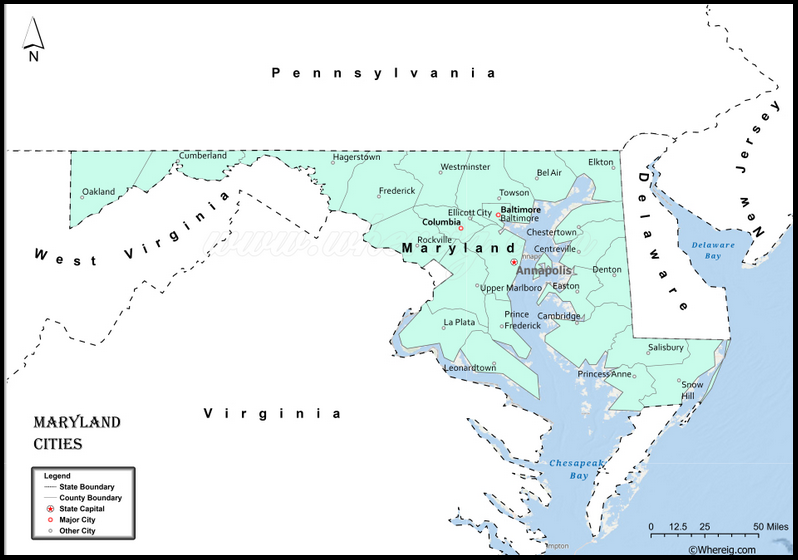
Maryland
MD
maryland.gov


| Rank | Name | 2021 Pop. | 2010 Census | Density (mi²) | Area (mi²) |
|---|---|---|---|---|---|
| 1 | Baltimore | 575,584 | 620,915 | 7,111 | 80.95 |
| 2 | Columbia | 103,991 | 99,615 | 3,256 | 31.94 |
| 3 | Germantown | 90,582 | 86,395 | 5,318 | 17.03 |
| 4 | Silver Spring | 81,773 | 71,452 | 10,371 | 7.88 |
| 5 | Waldorf | 75,489 | 67,752 | 2,082 | 36.26 |
| 6 | Frederick | 72,842 | 65,455 | 3,062 | 23.79 |
| 7 | Ellicott City | 72,665 | 65,834 | 2,425 | 29.96 |
| 8 | Glen Burnie | 69,872 | 67,639 | 4,033 | 17.32 |
| 9 | Rockville | 68,181 | 61,484 | 5,016 | 13.59 |
| 10 | Gaithersburg | 67,815 | 60,185 | 6,572 | 10.32 |
| 11 | Bethesda | 63,195 | 60,858 | 4,765 | 13.26 |
| 12 | Dundalk | 63,015 | 63,597 | 4,822 | 13.07 |
| 13 | Bowie | 58,709 | 55,458 | 2,969 | 19.77 |
| 14 | Towson | 57,817 | 55,197 | 4,085 | 14.15 |
| 15 | Aspen Hill | 53,049 | 48,759 | 5,528 | 9.6 |
| 16 | Severn | 50,496 | 44,231 | 2,756 | 18.32 |
| 17 | Wheaton | 50,229 | 48,284 | 7,281 | 6.9 |
| 18 | North Bethesda | 49,872 | 43,828 | 5,624 | 8.87 |
| 19 | Bel Air South | 48,425 | 47,709 | 3,092 | 15.66 |
| 20 | Potomac | 45,940 | 44,965 | 1,828 | 25.13 |
| 21 | Odenton | 41,846 | 37,132 | 2,832 | 14.77 |
| 22 | Catonsville | 41,547 | 41,567 | 2,976 | 13.96 |
| 23 | Woodlawn | 40,469 | 37,879 | 4,242 | 9.54 |
| 24 | Hagerstown | 40,030 | 39,779 | 3,290 | 12.17 |
| 25 | Essex | 39,437 | 39,262 | 4,259 | 9.26 |
| 26 | Annapolis | 39,241 | 38,407 | 5,444 | 7.21 |
| 27 | Clinton | 39,018 | 35,970 | 1,560 | 25.01 |
| 28 | Severna Park | 38,188 | 37,634 | 2,310 | 16.53 |
| 29 | Chillum | 35,557 | 33,513 | 10,464 | 3.4 |
| 30 | Randallstown | 35,528 | 32,430 | 3,476 | 10.22 |
| 31 | Olney | 35,191 | 33,844 | 2,173 | 16.19 |
| 32 | Owings Mills | 35,081 | 30,622 | 3,680 | 9.53 |
| 33 | Montgomery Village | 34,332 | 32,032 | 8,639 | 3.97 |
| 34 | Pikesville | 33,486 | 30,764 | 2,711 | 12.35 |
| 35 | Salisbury | 33,191 | 30,382 | 2,421 | 13.71 |
| 36 | College Park | 32,123 | 30,448 | 5,725 | 5.61 |
| 37 | Bel Air North | 31,941 | 30,568 | 2,001 | 15.96 |
| 38 | Parkville | 31,451 | 30,734 | 7,340 | 4.29 |
| 39 | Eldersburg | 31,108 | 30,531 | 781 | 39.84 |
| 40 | Carney | 30,289 | 29,941 | 4,345 | 6.97 |
| 41 | Milford Mill | 29,926 | 29,042 | 4,309 | 6.95 |
| 42 | Pasadena | 29,918 | 24,287 | 2,003 | 14.94 |
| 43 | Crofton | 29,136 | 27,348 | 4,406 | 6.61 |
| 44 | South Laurel | 28,683 | 26,112 | 3,554 | 8.07 |
| 45 | Perry Hall | 28,266 | 28,474 | 4,054 | 6.97 |
| 46 | Reisterstown | 27,007 | 25,968 | 5,229 | 5.17 |
| 47 | Ilchester | 26,974 | 23,476 | 2,515 | 10.73 |
| 48 | Lochearn | 25,771 | 25,333 | 4,610 | 5.59 |
| 49 | Edgewood | 25,574 | 25,562 | 1,438 | 17.78 |
| 50 | Laurel | 25,519 | 24,985 | 5,300 | 4.82 |
| 51 | Fairland | 25,220 | 23,681 | 5,090 | 4.96 |
| 52 | Middle River | 25,129 | 25,191 | 3,230 | 7.78 |
| 53 | North Laurel | 24,873 | 4,474 | 3,837 | 6.48 |
| 54 | Clarksburg | 24,767 | 13,766 | 3,015 | 8.21 |
| 55 | Suitland | 24,522 | 25,825 | 5,775 | 4.25 |
| 56 | Fort Washington | 24,237 | 23,717 | 1,757 | 13.79 |
| 57 | North Potomac | 23,914 | 24,410 | 3,666 | 6.52 |
| 58 | Arnold | 23,406 | 23,106 | 2,163 | 10.82 |
| 59 | Greenbelt | 23,200 | 22,186 | 3,721 | 6.24 |
| 60 | Landover | 22,553 | 23,078 | 5,640 | 4 |
| 61 | Camp Springs | 21,841 | 19,096 | 2,844 | 7.68 |
| 62 | Elkridge | 21,458 | 15,593 | 2,558 | 8.39 |
| 63 | Ballenger Creek | 21,080 | 18,274 | 1,951 | 10.8 |
| 64 | Cockeysville | 21,038 | 20,776 | 1,848 | 11.39 |
| 65 | Rosedale | 19,842 | 19,257 | 2,879 | 6.89 |
| 66 | Lake Shore | 19,791 | 19,477 | 1,474 | 13.43 |
| 67 | Langley Park | 19,520 | 18,755 | 19,638 | 0.99 |
| 68 | Arbutus | 19,292 | 20,483 | 2,956 | 6.53 |
| 69 | White Oak | 19,020 | 17,403 | 5,030 | 3.78 |
| 70 | Cumberland | 18,914 | 20,802 | 1,881 | 10.05 |
| 71 | Westminster | 18,674 | 18,514 | 2,796 | 6.68 |
| 72 | Seabrook | 18,616 | 17,287 | 6,050 | 3.08 |
| 73 | Hyattsville | 18,174 | 17,574 | 6,784 | 2.68 |
| 74 | Oxon Hill | 18,080 | 17,722 | 2,732 | 6.62 |
| 75 | Beltsville | 17,812 | 16,772 | 2,472 | 7.21 |
| 76 | Takoma Park | 17,751 | 16,802 | 8,493 | 2.09 |
| 77 | Maryland City | 17,513 | 16,093 | 2,269 | 7.72 |
| 78 | Redland | 17,414 | 17,242 | 2,473 | 7.04 |
| 79 | Ferndale | 17,208 | 16,746 | 4,329 | 3.98 |
| 80 | Parole | 17,074 | 15,922 | 1,663 | 10.27 |
| 81 | Glassmanor | 16,935 | 17,295 | 7,191 | 2.35 |
| 82 | Calverton | 16,888 | 17,724 | 3,683 | 4.59 |
| 83 | Easton | 16,871 | 16,289 | 1,472 | 11.46 |
| 84 | Glenmont | 16,659 | 13,529 | 5,950 | 2.8 |
| 85 | East Riverdale | 16,416 | 15,509 | 10,165 | 1.61 |
| 86 | Hillcrest Heights | 16,388 | 16,469 | 6,589 | 2.49 |
| 87 | Adelphi | 16,377 | 15,086 | 6,030 | 2.72 |
| 88 | Aberdeen | 15,935 | 14,976 | 2,459 | 6.48 |
| 89 | Elkton | 15,626 | 15,473 | 1,758 | 8.89 |
| 90 | Cloverly | 15,464 | 15,126 | 1,547 | 10 |
| 91 | Damascus | 15,250 | 15,257 | 1,320 | 11.56 |
| 92 | Rossville | 15,127 | 15,147 | 2,811 | 5.38 |
| 93 | Brooklyn Park | 14,850 | 14,373 | 3,526 | 4.21 |
| 94 | California | 14,815 | 11,857 | 1,151 | 12.87 |
| 95 | Kemp Mill | 14,733 | 12,564 | 5,903 | 2.5 |
| 96 | Havre de Grace | 14,472 | 13,039 | 2,473 | 5.85 |
| 97 | Summerfield | 14,343 | 10,898 | 3,940 | 3.64 |
| 98 | Colesville | 13,992 | 14,647 | 2,734 | 5.12 |
| 99 | Kettering | 13,527 | 12,790 | 2,463 | 5.49 |
| 100 | Glenn Dale | 13,361 | 13,466 | 1,868 | 7.15 |
| 101 | Bensville | 13,227 | 783 | 16.89 | |
| 102 | New Carrollton | 12,904 | 12,381 | 8,368 | 1.54 |
| 103 | Riviera Beach | 12,658 | 12,677 | 4,807 | 2.63 |
| 104 | Urbana | 12,587 | 9,175 | 1,901 | 6.62 |
| 105 | Annapolis Neck | 12,551 | 10,950 | 1,811 | 6.93 |
| 106 | Ocean Pines | 12,499 | 11,710 | 1,877 | 6.66 |
| 107 | Forestville | 12,342 | 12,353 | 3,143 | 3.93 |
| 108 | Joppatowne | 12,304 | 12,616 | 1,829 | 6.73 |
| 109 | Mays Chapel | 12,253 | 11,420 | 3,304 | 3.71 |
| 110 | Cambridge | 12,212 | 12,455 | 1,147 | 10.65 |
| 111 | Overlea | 12,195 | 12,275 | 4,061 | 3 |
| 112 | Brock Hall | 12,117 | 9,552 | 890 | 13.62 |
| 113 | Accokeek | 11,647 | 10,573 | 425 | 27.43 |
| 114 | Mitchellville | 11,547 | 10,967 | 2,339 | 4.94 |
| 115 | Travilah | 11,301 | 12,159 | 712 | 15.87 |
| 116 | Lanham | 11,120 | 10,157 | 3,152 | 3.53 |
| 117 | Lexington Park | 11,082 | 11,626 | 1,971 | 5.62 |
| 118 | Largo | 10,961 | 10,709 | 3,580 | 3.06 |
| 119 | Walker Mill | 10,904 | 11,302 | 3,454 | 3.16 |
| 120 | Halfway | 10,898 | 10,701 | 2,343 | 4.65 |
| 121 | Fort Meade | 10,873 | 9,327 | 1,325 | 8.21 |
| 122 | Timonium | 10,557 | 9,925 | 1,972 | 5.35 |
| 123 | Rosaryville | 10,501 | 10,697 | 1,143 | 9.19 |
| 124 | Linthicum | 10,442 | 10,324 | 1,912 | 5.46 |
| 125 | Bel Air | 10,273 | 10,149 | 3,383 | 3.04 |
| 126 | Friendly | 10,051 | 9,250 | 2,061 | 4.88 |
| 127 | La Plata | 9,983 | 8,802 | 1,343 | 7.43 |
| 128 | Lake Arbor | 9,973 | 9,776 | 3,182 | 3.13 |
| 129 | Westphalia | 9,944 | 7,266 | 749 | 13.27 |
| 130 | Brandywine | 9,849 | 6,719 | 468 | 21.04 |
| 131 | Burtonsville | 9,823 | 8,323 | 1,253 | 7.84 |
| 132 | Scaggsville | 9,751 | 1,937 | 5.04 | |
| 133 | Chesapeake Ranch Estates | 9,702 | 10,519 | 2,246 | 4.32 |
| 134 | Chevy Chase | 9,622 | 9,545 | 3,989 | 2.41 |
| 135 | Jessup | 9,509 | 7,137 | 1,810 | 5.25 |
| 136 | Mount Airy | 9,508 | 9,295 | 2,309 | 4.12 |
| 137 | Bladensburg | 9,396 | 8,995 | 9,491 | 0.99 |
| 138 | Marlboro Village | 9,325 | 9,438 | 2,425 | 3.85 |
| 139 | White Marsh | 9,216 | 9,513 | 1,736 | 5.31 |
| 140 | Edgewater | 9,112 | 9,023 | 3,045 | 2.99 |
| 141 | Linganore | 9,112 | 8,543 | 1,587 | 5.74 |
| 142 | Marlton | 9,071 | 9,031 | 1,529 | 5.93 |
| 143 | Leisure World | 9,040 | 8,749 | 8,196 | 1.1 |
| 144 | North Kensington | 9,036 | 9,514 | 5,929 | 1.52 |
| 145 | Fallston | 8,972 | 8,958 | 641 | 14 |
| 146 | South Kensington | 8,763 | 8,462 | 4,189 | 2.09 |
| 147 | Cape St. Claire | 8,729 | 8,747 | 4,351 | 2.01 |
| 148 | Coral Hills | 8,685 | 9,895 | 5,821 | 1.49 |
| 149 | Edgemere | 8,526 | 8,669 | 785 | 10.87 |
| 150 | Lansdowne | 8,477 | 8,409 | 3,725 | 2.28 |
| 151 | Frostburg | 8,391 | 9,009 | 2,511 | 3.34 |
| 152 | Garrison | 8,309 | 8,823 | 2,631 | 3.16 |
| 153 | Four Corners | 8,246 | 7,945 | 5,636 | 1.46 |
| 154 | Mount Rainier | 8,065 | 7,806 | 12,681 | 0.64 |
| 155 | Mayo | 8,031 | 8,298 | 1,429 | 5.62 |
| 156 | Baltimore Highlands | 7,944 | 7,019 | 4,581 | 1.73 |
| 157 | Temple Hills | 7,926 | 7,852 | 5,629 | 1.41 |
| 158 | Bryans Road | 7,847 | 7,244 | 510 | 15.38 |
| 159 | Robinwood | 7,684 | 6,918 | 1,991 | 3.86 |
| 160 | Stevensville | 7,267 | 6,803 | 1,128 | 6.44 |
| 161 | Thurmont | 7,223 | 6,203 | 2,332 | 3.1 |
| 162 | Riverdale Park | 7,180 | 6,943 | 4,547 | 1.58 |
| 163 | Ocean City | 6,948 | 7,105 | 1,533 | 4.53 |
| 164 | Lutherville | 6,856 | 6,504 | 3,243 | 2.11 |
| 165 | Taneytown | 6,839 | 6,752 | 2,167 | 3.16 |
| 166 | Brunswick | 6,787 | 5,890 | 2,079 | 3.27 |
| 167 | Walkersville | 6,721 | 5,838 | 1,411 | 4.76 |
| 168 | Woodlawn | 6,692 | 6,334 | 5,845 | 1.15 |
| 169 | Hillandale | 6,487 | 6,043 | 3,146 | 2.06 |
| 170 | Forest Glen | 6,469 | 6,582 | 6,355 | 1.02 |
| 171 | Darnestown | 6,462 | 6,802 | 393 | 16.44 |
| 172 | Savage | 6,428 | 7,054 | 2,349 | 2.74 |
| 173 | Hampstead | 6,421 | 6,322 | 1,938 | 3.31 |
| 174 | Bowleys Quarters | 6,412 | 6,755 | 2,039 | 3.15 |
| 175 | Cheverly | 6,410 | 6,185 | 4,856 | 1.32 |
| 176 | Fairwood | 6,261 | 5,031 | 1,834 | 3.41 |
| 177 | Glenarden | 6,139 | 5,844 | 5,142 | 1.19 |
| 178 | Chesapeake Beach | 6,094 | 5,784 | 2,263 | 2.69 |
| 179 | Riverside | 6,038 | 6,425 | 2,593 | 2.33 |
| 180 | Ashton-Sandy Spring | 5,997 | 5,628 | 585 | 10.25 |
| 181 | Naval Academy | 5,970 | 4,802 | 11,180 | 0.53 |
| 182 | District Heights | 5,964 | 5,756 | 6,895 | 0.86 |
| 183 | Cresawn | 5,916 | 4,592 | 968 | 6.11 |
| 184 | Spring Ridge | 5,876 | 5,795 | 2,228 | 2.64 |
| 185 | Marlow Heights | 5,872 | 5,618 | 2,888 | 2.03 |
| 186 | Fountainhead-Orchard Hills | 5,774 | 5,666 | 1,307 | 4.42 |
| 187 | Shady Side | 5,423 | 5,803 | 815 | 6.65 |
| 188 | Friendship Heights Village | 5,396 | 4,698 | 88,459 | 0.06 |
| 189 | Fruitland | 5,383 | 4,853 | 1,396 | 3.85 |
| 190 | Poolesville | 5,278 | 4,877 | 1,343 | 3.93 |
| 191 | Centreville | 5,234 | 4,261 | 1,912 | 2.74 |
| 192 | Layhill | 5,216 | 5,169 | 3,299 | 1.58 |
| 193 | Silver Hill | 5,120 | 5,950 | 3,824 | 1.34 |
| 194 | Chestertown | 5,027 | 5,281 | 1,723 | 2.92 |
| 195 | Middletown | 5,020 | 4,306 | 2,370 | 2.12 |
| 196 | Berlin | 4,998 | 4,457 | 1,486 | 3.36 |
| 197 | Manchester | 4,859 | 4,814 | 2,077 | 2.34 |
| 198 | Seat Pleasant | 4,730 | 4,534 | 6,375 | 0.74 |
| 199 | Deale | 4,706 | 4,945 | 886 | 5.31 |
| 200 | Chester | 4,658 | 4,167 | 889 | 5.24 |
| 201 | Hampton | 4,624 | 5,052 | 808 | 5.73 |
| 202 | Woodmore | 4,608 | 3,936 | 704 | 6.55 |
| 203 | Peppermill Village | 4,575 | 4,895 | 6,108 | 0.75 |
| 204 | Denton | 4,562 | 4,397 | 866 | 5.27 |
| 205 | Capitol Heights | 4,508 | 4,312 | 5,772 | 0.78 |
| 206 | Perryville | 4,443 | 4,341 | 1,498 | 2.96 |
| 207 | Kingsville | 4,385 | 4,318 | 437 | 10.04 |
| 208 | West Laurel | 4,383 | 4,230 | 1,937 | 2.26 |
| 209 | Fulton | 4,326 | 2,049 | 1,143 | 3.79 |
| 210 | West Ocean City | 4,310 | 4,375 | 1,141 | 3.78 |
| 211 | National Harbor | 4,296 | 3,788 | 2,947 | 1.46 |
| 212 | Melwood | 4,289 | 1,536 | 2.79 | |
| 213 | Pocomoke City | 4,158 | 4,182 | 1,107 | 3.75 |
| 214 | Riva | 4,130 | 4,076 | 1,681 | 2.46 |
| 215 | Sykesville | 3,970 | 3,944 | 2,519 | 1.58 |
| 216 | Leonardtown | 3,944 | 3,024 | 1,037 | 3.8 |
| 217 | Brookmont | 3,921 | 3,468 | 2,991 | 1.31 |
| 218 | St. James | 3,860 | 2,953 | 639 | 6.04 |
| 219 | Pleasant Hills | 3,821 | 3,379 | 876 | 4.36 |
| 220 | Indian Head | 3,794 | 3,865 | 3,080 | 1.23 |
| 221 | Boonsboro | 3,791 | 3,461 | 1,242 | 3.05 |
| 222 | North East | 3,660 | 3,586 | 1,809 | 2.02 |
| 223 | Delmar | 3,606 | 3,099 | 2,134 | 1.69 |
| 224 | Princess Anne | 3,519 | 3,334 | 2,102 | 1.67 |
| 225 | Grasonville | 3,495 | 3,425 | 632 | 5.53 |
| 226 | Huntingtown | 3,486 | 432 | 8.07 | |
| 227 | Marlboro Meadows | 3,468 | 3,672 | 569 | 6.1 |
| 228 | Brentwood | 3,465 | 3,349 | 9,000 | 0.39 |
| 229 | La Vale | 3,429 | 3,551 | 1,286 | 2.67 |
| 230 | Emmitsburg | 3,338 | 2,820 | 2,222 | 1.5 |
| 231 | Berwyn Heights | 3,245 | 3,131 | 4,676 | 0.69 |
| 232 | Springdale | 3,199 | 2,994 | 3,935 | 0.81 |
| 233 | Andrews AFB | 3,079 | 2,973 | 444 | 6.93 |
| 234 | Paramount-Long Meadow | 3,062 | 2,571 | 1,403 | 2.18 |
| 235 | Golden Beach | 3,060 | 3,796 | 807 | 3.79 |
| 236 | Jarrettsville | 3,023 | 2,916 | 350 | 8.63 |
| 237 | Chevy Chase | 2,988 | 2,834 | 6,426 | 0.47 |
| 238 | Smithsburg | 2,964 | 2,995 | 2,823 | 1.05 |
| 239 | Prince Frederick | 2,928 | 2,538 | 800 | 3.66 |
| 240 | Braddock Heights | 2,910 | 2,608 | 620 | 4.69 |
| 241 | Aberdeen Proving Ground | 2,872 | 2,093 | 258 | 11.13 |
| 242 | Gambrills | 2,837 | 2,800 | 376 | 7.55 |
| 243 | Rising Sun | 2,773 | 2,793 | 1,704 | 1.63 |
| 244 | Herald Harbor | 2,747 | 2,603 | 1,636 | 1.68 |
| 245 | Federalsburg | 2,653 | 2,735 | 1,375 | 1.93 |
| 246 | Dunkirk | 2,638 | 401 | 6.59 | |
| 247 | University Park | 2,613 | 2,559 | 5,216 | 0.5 |
| 248 | Crisfield | 2,564 | 2,713 | 1,477 | 1.74 |
| 249 | Forest Heights | 2,552 | 2,475 | 5,476 | 0.47 |
| 250 | Maugansville | 2,543 | 3,071 | 1,039 | 2.45 |
| 251 | Konterra | 2,536 | 2,527 | 418 | 6.07 |
| 252 | Owings | 2,528 | 2,149 | 642 | 3.94 |
| 253 | Adamstown | 2,512 | 2,372 | 764 | 3.29 |
| 254 | Perryman | 2,412 | 2,342 | 440 | 5.48 |
| 255 | Kensington | 2,333 | 2,209 | 4,912 | 0.47 |
| 256 | Hughesville | 2,279 | 2,197 | 204 | 11.15 |
| 257 | Wilson-Conococheague | 2,263 | 2,282 | 480 | 4.72 |
| 258 | Jefferson | 2,235 | 2,111 | 1,065 | 2.1 |
| 259 | Drum Point | 2,227 | 2,731 | 1,338 | 1.67 |
| 260 | Croom | 2,174 | 2,631 | 64 | 34.19 |
| 261 | Long Beach | 2,143 | 1,821 | 1,283 | 1.67 |
| 262 | Solomons | 2,132 | 2,368 | 1,071 | 1.99 |
| 263 | Cabin John | 2,121 | 2,280 | 1,799 | 1.18 |
| 264 | Williamsport | 2,081 | 2,087 | 2,117 | 0.98 |
| 265 | Spencerville | 2,079 | 1,594 | 1,331 | 1.56 |
| 266 | Chevy Chase Village | 2,062 | 1,957 | 4,910 | 0.42 |
| 267 | North Beach | 2,057 | 1,979 | 6,252 | 0.33 |
| 268 | Mountain Lake Park | 2,056 | 2,162 | 1,074 | 1.92 |
| 269 | Snow Hill | 2,048 | 2,119 | 676 | 3.03 |
| 270 | Hurlock | 2,026 | 2,107 | 759 | 2.67 |
| 271 | Myersville | 1,926 | 1,646 | 1,829 | 1.05 |
| 272 | Queensland | 1,918 | 395 | 4.85 | |
| 273 | Kingstown | 1,917 | 1,733 | 846 | 2.27 |
| 274 | Derwood | 1,890 | 2,381 | 3,014 | 0.63 |
| 275 | Greensboro | 1,883 | 1,909 | 1,753 | 1.07 |
| 276 | Arden on the Severn | 1,880 | 1,953 | 1,316 | 1.43 |
| 277 | Charlotte Hall | 1,865 | 1,420 | 368 | 5.06 |
| 278 | Point of Rocks | 1,857 | 1,466 | 1,687 | 1.1 |
| 279 | Lusby | 1,824 | 1,835 | 519 | 3.51 |
| 280 | Oakland | 1,799 | 1,895 | 663 | 2.71 |
| 281 | Mechanicsville | 1,765 | 1,508 | 340 | 5.19 |
| 282 | Baden | 1,743 | 2,128 | 63 | 27.6 |
| 283 | Bartonsville | 1,707 | 1,451 | 654 | 2.61 |
| 284 | Westernport | 1,692 | 1,880 | 1,925 | 0.88 |
| 285 | Ridgely | 1,667 | 1,638 | 894 | 1.86 |
| 286 | Landover Hills | 1,634 | 1,579 | 4,452 | 0.37 |
| 287 | Bel Air | 1,579 | 1,258 | 3,463 | 0.46 |
| 288 | Crownsville | 1,530 | 1,757 | 301 | 5.09 |
| 289 | Hancock | 1,523 | 1,558 | 552 | 2.76 |
| 290 | Fairmount Heights | 1,520 | 1,455 | 5,736 | 0.27 |
| 291 | Pittsville | 1,490 | 1,428 | 976 | 1.53 |
| 292 | Edmonston | 1,488 | 1,431 | 3,647 | 0.41 |
| 293 | Colmar Manor | 1,448 | 1,407 | 3,375 | 0.43 |
| 294 | New Windsor | 1,400 | 1,393 | 1,884 | 0.74 |
| 295 | Cottage City | 1,350 | 1,308 | 4,963 | 0.27 |
| 296 | Woodsboro | 1,325 | 1,146 | 1,874 | 0.71 |
| 297 | Potomac Heights | 1,289 | 1,117 | 1,201 | 1.07 |
| 298 | Buckeystown | 1,286 | 1,019 | 841 | 1.53 |
| 299 | Morningside | 1,279 | 1,222 | 2,224 | 0.57 |
| 300 | Rock Hall | 1,278 | 1,308 | 955 | 1.34 |
| 301 | Somerset | 1,271 | 1,207 | 4,639 | 0.27 |
| 302 | Algonquin | 1,237 | 1,241 | 1,647 | 0.75 |
| 303 | Keedysville | 1,233 | 1,153 | 1,359 | 0.91 |
| 304 | Bowling Green | 1,217 | 1,077 | 1,265 | 0.96 |
| 305 | Highland | 1,206 | 1,034 | 501 | 2.41 |
| 306 | Charlestown | 1,198 | 1,179 | 1,025 | 1.17 |
| 307 | Cavetown | 1,129 | 1,473 | 593 | 1.9 |
| 308 | Hebron | 1,104 | 1,082 | 841 | 1.31 |
| 309 | Lonaconing | 1,087 | 1,187 | 3,003 | 0.36 |
| 310 | Pylesville | 1,084 | 693 | 228 | 4.74 |
| 311 | St. Michaels | 1,062 | 1,030 | 916 | 1.16 |
| 312 | Garrett Park | 1,053 | 996 | 4,113 | 0.26 |
| 313 | Queen Anne | 1,049 | 1,280 | 120 | 8.71 |
| 314 | Willards | 1,017 | 967 | 894 | 1.14 |
| 315 | Tilghman Island | 1,005 | 784 | 419 | 2.4 |
| 316 | Trappe | 1,000 | 1,068 | 375 | 2.67 |
| 317 | Libertytown | 993 | 950 | 412 | 2.41 |
| 318 | Martin’s Additions | 993 | 945 | 7,196 | 0.14 |
| 319 | Chevy Chase View | 980 | 929 | 3,657 | 0.27 |
| 320 | Mount Vernon | 966 | 779 | 74 | 13.03 |
| 321 | Union Bridge | 963 | 975 | 922 | 1.04 |
| 322 | Calvert Beach | 960 | 808 | 1,165 | 0.82 |
| 323 | Aquasco | 957 | 981 | 48 | 19.78 |
| 324 | Monrovia | 903 | 416 | 402 | 2.25 |
| 325 | Tilghmanton | 868 | 465 | 1,871 | 0.46 |
| 326 | Funkstown | 867 | 883 | 2,356 | 0.37 |
| 327 | Grantsville | 859 | 891 | 828 | 1.04 |
| 328 | Cobb Island | 846 | 1,166 | 1,351 | 0.63 |
| 329 | Potomac Park | 818 | 2,530 | 2,119 | 0.39 |
| 330 | Highfield-Cascade | 809 | 1,112 | 467 | 1.73 |
| 331 | Piney Point | 794 | 864 | 519 | 1.53 |
| 332 | Chevy Chase Section Three | 792 | 759 | 6,769 | 0.12 |
| 333 | Bishopville | 774 | 531 | 270 | 2.86 |
| 334 | New Market | 770 | 668 | 474 | 1.62 |
| 335 | Finzel | 767 | 547 | 195 | 3.94 |
| 336 | Eden | 765 | 823 | 137 | 5.58 |
| 337 | Port Deposit | 765 | 759 | 338 | 2.26 |
| 338 | Mount Savage | 747 | 873 | 811 | 0.92 |
| 339 | Church Hill | 743 | 752 | 1,035 | 0.72 |
| 340 | Queenstown | 703 | 668 | 350 | 2.01 |
| 341 | Preston | 701 | 721 | 1,296 | 0.54 |
| 342 | Chevy Chase Section Five | 700 | 670 | 6,542 | 0.11 |
| 343 | Chesapeake City | 693 | 689 | 1,308 | 0.53 |
| 344 | McCoole | 692 | 511 | 493 | 1.4 |
| 345 | Mount Aetna | 689 | 561 | 488 | 1.41 |
| 346 | Sharwn | 678 | 656 | 1,603 | 0.42 |
| 347 | Upper Marlboro | 675 | 686 | 1,642 | 0.41 |
| 348 | Cecilton | 672 | 663 | 1,391 | 0.48 |
| 349 | Eckhart Mines | 665 | 932 | 437 | 1.52 |
| 350 | Galesville | 645 | 684 | 497 | 1.3 |
| 351 | Sharpsburg | 643 | 660 | 2,977 | 0.22 |
| 352 | Bryantown | 637 | 655 | 154 | 4.14 |
| 353 | Cordova | 612 | 562 | 126 | 4.87 |
| 354 | Oxford | 608 | 650 | 1,130 | 0.54 |
| 355 | Tall Timbers | 602 | 462 | 438 | 1.38 |
| 356 | North Chevy Chase | 601 | 562 | 5,137 | 0.12 |
| 357 | Millington | 598 | 650 | 835 | 0.72 |
| 358 | Fairlee | 591 | 490 | 156 | 3.79 |
| 359 | Galena | 582 | 609 | 1,612 | 0.36 |
| 360 | Newark | 572 | 336 | 60 | 9.51 |
| 361 | Bowmans Addition | 571 | 627 | 580 | 0.98 |
| 362 | Washington Grove | 565 | 531 | 1,692 | 0.33 |
| 363 | Corriganville | 559 | 455 | 1,437 | 0.39 |
| 364 | North Brentwood | 547 | 530 | 4,841 | 0.11 |
| 365 | Cedarville | 539 | 717 | 41 | 13.28 |
| 366 | Loch Lynn Heights | 528 | 548 | 1,660 | 0.32 |
| 367 | Pomfret | 519 | 517 | 189 | 2.74 |
| 368 | Kent Narrows | 511 | 567 | 543 | 0.94 |
| 369 | Secretary | 500 | 529 | 1,718 | 0.29 |
| 370 | Darlington | 499 | 409 | 478 | 1.04 |
| 371 | St. Leonard | 494 | 742 | 216 | 2.29 |
| 372 | Pleasant Grove | 476 | 353 | 301 | 1.58 |
| 373 | Friendsville | 471 | 502 | 471 | 1 |
| 374 | Chance | 470 | 353 | 281 | 1.67 |
| 375 | Rawlings | 469 | 693 | 525 | 0.89 |
| 376 | Sudlersville | 464 | 483 | 305 | 1.52 |
| 377 | Leitersburg | 460 | 573 | 263 | 1.75 |
| 378 | Allen | 453 | 210 | 1,287 | 0.35 |
| 379 | Mount Lena | 451 | 515 | 360 | 1.25 |
| 380 | Kennedyville | 436 | 199 | 780 | 0.56 |
| 381 | Fairplay | 435 | 580 | 361 | 1.2 |
| 382 | Broomes Island | 421 | 405 | 579 | 0.73 |
| 383 | Parsonsburg | 420 | 339 | 321 | 1.31 |
| 384 | Barton | 419 | 454 | 2,024 | 0.21 |
| 385 | Midland | 404 | 450 | 2,557 | 0.16 |
| 386 | Ellerslie | 390 | 572 | 1,026 | 0.38 |
| 387 | Midlothian | 388 | 320 | 627 | 0.62 |
| 388 | Bagtown | 386 | 333 | 707 | 0.55 |
| 389 | Laytonsville | 381 | 358 | 360 | 1.06 |
| 390 | East New Market | 377 | 390 | 943 | 0.4 |
| 391 | Zihlman | 369 | 362 | 246 | 1.5 |
| 392 | Fairmount | 367 | 457 | 30 | 12.26 |
| 393 | Clear Spring | 366 | 364 | 3,183 | 0.12 |
| 394 | Deer Park | 364 | 382 | 364 | 1 |
| 395 | St. George Island | 357 | 257 | 454 | 0.79 |
| 396 | Sabillasville | 354 | 354 | 236 | 1.5 |
| 397 | Mardela Springs | 353 | 347 | 869 | 0.41 |
| 398 | Deal Island | 351 | 471 | 116 | 3.03 |
| 399 | Shaft | 351 | 235 | 447 | 0.79 |
| 400 | Tolchester | 350 | 329 | 574 | 0.61 |
Baltimore
Population: Baltimore, the largest city in Maryland, has over 590,000 residents.
Area: Baltimore covers approximately 92.1 square miles.
Zip Codes: Baltimore has various zip codes, including 21201, 21202, 21218.
Area Codes: 410, 443
County Affiliated: Independent city
Latitude: 39.2904° N
Longitude: 76.6122° W
Baltimore is a vibrant city known for its historic neighborhoods, cultural institutions, and scenic waterfront. Inner Harbor is a bustling waterfront area featuring attractions such as the National Aquarium, USS Constellation, and Maryland Science Center, as well as restaurants, shops, and entertainment venues, offering activities such as boat tours, paddleboats, and street performances. Fort McHenry is a historic fortress and national monument famous for its role in the War of 1812 and inspiring the national anthem, featuring guided tours, exhibits, and reenactments, as well as scenic views of Baltimore Harbor and the Chesapeake Bay. Fells Point is a historic district known for its cobblestone streets, waterfront views, and lively nightlife, featuring bars, restaurants, and shops housed in historic buildings, as well as attractions such as Broadway Square, Robert Long House, and Thames Street Park.
Columbia
Population: Columbia, situated between Baltimore and Washington D.C., has over 100,000 residents.
Area: Columbia covers approximately 32.2 square miles.
Zip Codes: Columbia has various zip codes, including 21044, 21045, 21046.
Area Codes: 410, 443, 667
County Affiliated: Howard County
Latitude: 39.2037° N
Longitude: 76.8610° W
Columbia is a planned community known for its quality of life, diverse neighborhoods, and recreational amenities. Merriweather Post Pavilion is an outdoor amphitheater and concert venue hosting live performances by musicians, comedians, and other entertainers, as well as events such as music festivals, film screenings, and community gatherings, surrounded by wooded parkland and walking trails. Lake Kittamaqundi is a scenic lake and focal point of downtown Columbia, featuring walking paths, green spaces, and public art installations, as well as recreational activities such as paddleboats, fishing, and picnicking, as well as events such as outdoor concerts, art shows, and holiday celebrations. The Mall in Columbia is a shopping center and retail destination featuring anchor stores, specialty shops, and dining options, as well as amenities such as a food court, movie theater, and events such as sales, promotions, and seasonal festivities.
Germantown
Population: Germantown, located in Montgomery County, has over 90,000 residents.
Area: Germantown covers approximately 10.9 square miles.
Zip Codes: Germantown has various zip codes, including 20874, 20876.
Area Codes: 301, 240
County Affiliated: Montgomery County
Latitude: 39.1732° N
Longitude: 77.2717° W
Germantown is a suburban community known for its family-friendly neighborhoods, parks, and recreational facilities. BlackRock Center for the Arts is a cultural institution and performing arts venue showcasing live theater productions, musical performances, and visual arts exhibitions, as well as educational programs, workshops, and community events for residents of all ages. Seneca Creek State Park is a scenic outdoor recreation area featuring hiking trails, picnicking areas, and waterfront activities such as fishing, boating, and kayaking, as well as nature programs, ranger-led tours, and special events such as summer concerts and wildlife festivals. Maryland SoccerPlex is a sports complex and athletic facility hosting soccer tournaments, leagues, and training programs, as well as events such as youth sports tournaments, college showcases, and community festivals.
Silver Spring
Population: Silver Spring, located near Washington D.C., has over 80,000 residents.
Area: Silver Spring covers approximately 7.92 square miles.
Zip Codes: Silver Spring has various zip codes, including 20901, 20902, 20910.
Area Codes: 301, 240
County Affiliated: Montgomery County
Latitude: 38.9907° N
Longitude: 77.0261° W
Silver Spring is an urban community known for its cultural diversity, arts scene, and recreational opportunities. AFI Silver Theatre and Cultural Center is a historic theater and cultural institution showcasing independent films, documentaries, and classic movies, as well as film festivals, filmmaker discussions, and educational programs for film enthusiasts of all ages. Downtown Silver Spring is a vibrant commercial district featuring shops, restaurants, and entertainment venues, as well as public art installations, seasonal events, and community gatherings, offering activities such as outdoor concerts, farmers’ markets, and street performances. Acorn Park is a green space and public square featuring a historic marker commemorating the founding of Silver Spring, as well as benches, walking paths, and landscaped gardens, providing a tranquil oasis in the heart of downtown.
Frederick
Population: Frederick, located in Frederick County, has over 70,000 residents.
Area: Frederick covers approximately 23.55 square miles.
Zip Codes: Frederick has various zip codes, including 21701, 21702, 21703.
Area Codes: 301, 240
County Affiliated: Frederick County
Latitude: 39.4143° N
Longitude: 77.4105° W
Frederick is a historic city known for its charming downtown, cultural attractions, and scenic surroundings. Historic Downtown Frederick is a designated area featuring historic buildings, boutique shops, and art galleries, as well as restaurants, cafes, and breweries housed in restored warehouses and storefronts, offering activities such as guided tours, ghost walks, and special events such as First Saturday celebrations and holiday festivals. Baker Park is a picturesque urban park featuring walking paths, green spaces, and recreational amenities such as tennis courts, playgrounds, and picnic areas, as well as attractions such as Culler Lake, a scenic pond with fountains and wildlife, as well as events such as outdoor concerts, art shows, and fitness classes. National Museum of Civil War Medicine is a cultural institution and historic site showcasing exhibits and artifacts related to medical practices during the Civil War, featuring interactive displays, medical instruments, and interpretive programs on topics such as battlefield medicine, nursing, and public health.
Rockville
Population: Rockville, located in Montgomery County, has over 60,000 residents.
Area: Rockville covers approximately 13.03 square miles.
Zip Codes: Rockville has various zip codes, including 20850, 20851, 20852.
Area Codes: 301, 240
County Affiliated: Montgomery County
Latitude: 39.0837° N
Longitude: 77.1537° W
Rockville is a suburban city known for its diverse neighborhoods, cultural amenities, and economic opportunities. Rockville Town Square is a mixed-use development featuring shops, restaurants, and residential units, as well as a public plaza, performance stage, and seasonal events such as farmers’ markets, outdoor concerts, and holiday celebrations, offering activities such as ice skating, movie nights, and art installations. Glenview Mansion and Civic Center Park is a historic estate and public park featuring walking trails, gardens, and scenic overlooks, as well as attractions such as Glenview Mansion, a historic house museum with period furnishings and art collections, as well as rental facilities for weddings, parties, and special events. Montgomery College-Rockville Campus is a community college and educational institution offering academic programs, workforce training, and cultural events, as well as facilities such as libraries, theaters, and athletic fields, serving students of all ages and backgrounds.
Gaithersburg
Population: Gaithersburg, located in Montgomery County, has over 65,000 residents.
Area: Gaithersburg covers approximately 10.34 square miles.
Zip Codes: Gaithersburg has various zip codes, including 20877, 20878, 20879.
Area Codes: 301, 240
County Affiliated: Montgomery County
Latitude: 39.1434° N
Longitude: 77.2014° W
Gaithersburg is a suburban community known for its economic diversity, cultural attractions, and family-friendly amenities. RIO Washingtonian Center is a waterfront development featuring shops, restaurants, and entertainment venues, as well as a scenic lake, paddleboat rentals, and outdoor concerts, offering activities such as dining cruises, carousel rides, and seasonal events such as festivals, fireworks displays, and holiday celebrations. Kentlands is a planned community and mixed-use development featuring residential neighborhoods, commercial districts, and recreational facilities, as well as parks, playgrounds, and walking trails, as well as amenities such as community centers, swimming pools, and tennis courts, offering activities such as outdoor concerts, art shows, and farmers’ markets. Gaithersburg Community Museum is a cultural institution and historic site showcasing exhibits and artifacts related to the history and heritage of Gaithersburg, featuring galleries, collections, and educational programs on topics such as agriculture, industry, and transportation, as well as events such as guided tours, lectures, and workshops.
Bowie
Population: Bowie, located in Prince George’s County, has over 55,000 residents.
Area: Bowie covers approximately 18.02 square miles.
Zip Codes: Bowie has various zip codes, including 20715, 20716, 20720.
Area Codes: 301, 240
County Affiliated: Prince George’s County
Latitude: 38.9822° N
Longitude: 76.7432° W
Bowie is a suburban city known for its residential neighborhoods, parks, and cultural amenities. Bowie Town Center is a shopping mall and retail destination featuring anchor stores, specialty shops, and dining options, as well as amenities such as a food court, movie theater, and events such as sales, promotions, and seasonal festivities. Allen Pond Park is a recreational area and community park featuring walking trails, sports fields, and playgrounds, as well as amenities such as picnic areas, fishing piers, and paddleboat rentals, offering activities such as birdwatching, nature walks, and outdoor concerts. Belair Mansion is a historic estate and museum showcasing exhibits and artifacts related to the history and heritage of Bowie, featuring period furnishings, art collections, and gardens, as well as guided tours, educational programs, and special events such as tea parties, craft workshops, and historical reenactments.
Annapolis
Population: Annapolis, the capital of Maryland, has over 39,000 residents.
Area: Annapolis covers approximately 8.10 square miles.
Zip Codes: Annapolis has various zip codes, including 21401, 21403, 21409.
Area Codes: 410, 443
County Affiliated: Anne Arundel County
Latitude: 38.9784° N
Longitude: 76.4922° W
Annapolis is a historic city known for its colonial architecture, maritime heritage, and government institutions. United States Naval Academy is a prestigious military academy and historic landmark, featuring academic buildings, museums, and naval vessels, as well as attractions such as Bancroft Hall, Chapel Dome, and John Paul Jones Crypt, offering guided tours, events, and public access to select areas of campus and waterfront. City Dock is a scenic waterfront area featuring marinas, boat docks, and outdoor cafes, as well as attractions such as Ego Alley, Market House, and Susan Campbell Park, offering activities such as sailing, cruising, and sightseeing tours of Chesapeake Bay and historic landmarks. Maryland State House is a historic government building and state capitol, featuring legislative chambers, ceremonial halls, and a domed rotunda, as well as attractions such as Old Senate Chamber, Governor’s Reception Room, and George Washington Inaugural Bible, offering guided tours, exhibits, and educational programs on Maryland’s colonial history, government, and civic life.
Towns and Cities of Maryland
A
- Aberdeen Proving Ground, MD
- Aberdeen, MD
- Accident, MD
- Accokeek, MD
- Andrews Air Force Base, MD
- Annapolis, MD
- Arnold, MD
- Ashton, MD
B
- Baltimore, MD
- Barclay, MD
- Barnesville, MD
- Barton, MD
- Bel Air, MD
- Beltsville, MD
- Berlin, MD
- Bethesda, MD
- Betterton, MD
- Bladensburg, MD
- Boonsboro, MD
- Bowie, MD
- Braddock Heights, MD
- Brandywine, MD
- Brentwood, MD
- Brookeville, MD
- Brooklyn, MD
- Brunswick, MD
- Bryans Road, MD
- Burkittsville, MD
- Burtonsville, MD
C
- Cabin John, MD
- California, MD
- Cambridge, MD
- Capitol Heights, MD
- Catonsville, MD
- Cavetown, MD
- Cecilton, MD
- Centreville, MD
- Charlestown, MD
- Charlotte Hall, MD
- Chesapeake Beach, MD
- Chester, MD
- Chestertown, MD
- Chevy Chase, MD
- Chewsville, MD
- Church Creek, MD
- Church Hill, MD
- Clarksburg, MD
- Clear Spring, MD
- Clinton, MD
- Cockeysville, MD
- College Park, MD
- Columbia, MD
- Cordova, MD
- Crisfield, MD
- Crofton, MD
- Crownsville, MD
- Cumberland, MD
D
- Damascus, MD
- Deal Island, MD
- Deale, MD
- Delmar, MD
- Denton, MD
- District Heights, MD
- Dundalk, MD
- Dunkirk, MD
E
- East New Market, MD
- Easton, MD
- Eden, MD
- Edgewood, MD
- Elkridge, MD
- Elkton, MD
- Ellicott City, MD
- Emmitsburg, MD
- Essex, MD
F
- Fallston, MD
- Federalsburg, MD
- Forest Hill, MD
- Fort Washington, MD
- Frederick, MD
- Friendship, MD
- Friendsville, MD
- Frostburg, MD
- Fruitland, MD
- Funkstown, MD
G
- Gaithersburg, MD
- Galena, MD
- Garrett Park, MD
- Garrison, MD
- Germantown, MD
- Glen Burnie, MD
- Glen Echo, MD
- Glenn Dale, MD
- Goldsboro, MD
- Grantsville, MD
- Grasonville, MD
- Greenbelt, MD
- Greensboro, MD
H
- Hagerstown, MD
- Hampstead, MD
- Hancock, MD
- Havre De Grace, MD
- Hebron, MD
- Henderson, MD
- Highland, MD
- Hillsboro, MD
- Hughesville, MD
- Huntingtown, MD
- Hurlock, MD
- Hyattsville, MD
I
- Indian Head, MD
J
- Jarrettsville, MD
- Jessup, MD
- Joppa, MD
K
- Keedysville, MD
- Kensington, MD
- Kingsville, MD
- Kitzmiller, MD
L
- La Plata, MD
- Lanham, MD
- Laurel, MD
- Leonardtown, MD
- Lexington Park, MD
- Linthicum Heights, MD
- Lonaconing, MD
- Luke, MD
- Lusby, MD
- Lutherville Timonium, MD
M
- Manchester, MD
- Mardela Springs, MD
- Marydel, MD
- Maryland Line, MD
- Maugansville, MD
- Mayo, MD
- Middle River, MD
- Middletown, MD
- Midland, MD
- Millington, MD
- Montgomery Village, MD
- Mount Airy, MD
- Mount Rainier, MD
- Myersville, MD
N
- New Market, MD
- New Windsor, MD
- Newark, MD
- North Beach, MD
- North East, MD
O
- Oakland, MD
- Ocean City, MD
- Odenton, MD
- Olney, MD
- Owings Mills, MD
- Owings, MD
- Oxford, MD
- Oxon Hill, MD
P
- Parkville, MD
- Pasadena, MD
- Perry Hall, MD
- Perryman, MD
- Perryville, MD
- Pikesville, MD
- Pittsville, MD
- Poolesville, MD
- Port Deposit, MD
- Port Tobacco, MD
- Potomac, MD
- Preston, MD
- Prince Frederick, MD
- Princess Anne, MD
Q
- Queen Anne, MD
- Queenstown, MD
R
- Randallstown, MD
- Reisterstown, MD
- Ridgely, MD
- Rising Sun, MD
- Riva, MD
- Riverdale, MD
- Rock Hall, MD
- Rockville, MD
- Rosedale, MD
S
- Saint James, MD
- Saint Leonard, MD
- Saint Michaels, MD
- Salisbury, MD
- Savage, MD
- Secretary, MD
- Severn, MD
- Severna Park, MD
- Shady Side, MD
- Sharpsburg, MD
- Sharptown, MD
- Silver Spring, MD
- Smithsburg, MD
- Snow Hill, MD
- Solomons, MD
- Stevensville, MD
- Sudlersville, MD
- Suitland, MD
- Sykesville, MD
T
- Takoma Park, MD
- Taneytown, MD
- Temple Hills, MD
- Templeville, MD
- Thurmont, MD
- Tilghman, MD
- Towson, MD
- Trappe, MD
U
- Union Bridge, MD
- Upper Marlboro, MD
V
- Vienna, MD
W
- Waldorf, MD
- Walkersville, MD
- Washington Grove, MD
- Westernport, MD
- Westminster, MD
- White Marsh, MD
- Willards, MD
- Williamsport, MD
- Woodsboro, MD
Counties of Maryland
1. Montgomery County
County Seat: Rockville
- Area: 507 square miles
- Population: Approximately 1,062,061
- Area Codes: 240, 301
- Latitude and Longitude: 39.1362° N, 77.2014° W
Location and History
Montgomery County, located in the central part of Maryland, borders Washington, D.C., to the southwest and stretches northward towards Frederick County. Established in 1776, the county was named after Richard Montgomery, a Revolutionary War general. The region historically served as an agricultural center, with tobacco as the main crop. Over the years, the county has transformed into a suburban area with a blend of residential, commercial, and high-tech industries. The development of the Capital Beltway in the 1960s catalyzed its suburban growth, making it one of the most affluent counties in the United States.
Major Highways and Landmarks
Montgomery County is crisscrossed by major highways, including Interstate 270, the Capital Beltway (I-495), and U.S. Route 29. These highways connect the county to Washington, D.C., and other parts of Maryland, fostering significant commuter traffic. Notable landmarks include the National Institutes of Health (NIH) in Bethesda, the headquarters of the Food and Drug Administration (FDA) in White Oak, and the historic Great Falls Park along the Potomac River. The county is also home to the vibrant city of Rockville, with its historic downtown area, and the bustling Bethesda Row, known for its dining, shopping, and entertainment options.
2. Prince George’s County
County Seat: Upper Marlboro
- Area: 498 square miles
- Population: Approximately 967,201
- Area Codes: 240, 301
- Latitude and Longitude: 38.7849° N, 76.8721° W
Location and History
Prince George’s County is situated in the central part of Maryland, to the east of Washington, D.C. The county was founded in 1696 and named after Prince George of Denmark, the husband of Queen Anne of Great Britain. Historically, the county was an agrarian society dominated by tobacco plantations, supported by enslaved labor. With the expansion of the federal government and the growth of Washington, D.C., Prince George’s County developed into a suburban community, with significant residential and commercial growth during the 20th century.
Major Highways and Landmarks
The county is well-connected by major highways, including the Capital Beltway (I-495), U.S. Route 50, and the Baltimore-Washington Parkway (MD 295). These routes facilitate access to Washington, D.C., and Baltimore, contributing to the county’s role as a crucial commuter area. Landmarks in Prince George’s County include the University of Maryland, College Park, which is the state’s flagship university, and the National Harbor, a large waterfront development along the Potomac River. The county is also home to FedExField, the stadium for the Washington Commanders, and the NASA Goddard Space Flight Center, a major research laboratory for space exploration.
3. Baltimore County
County Seat: Towson
- Area: 682 square miles
- Population: Approximately 854,535
- Area Codes: 410, 443, 667
- Latitude and Longitude: 39.4648° N, 76.5290° W
Location and History
Baltimore County is located in the northern part of Maryland, surrounding but not including the independent city of Baltimore. The county was established in 1659 and has a rich history tied to the development of the Baltimore metropolitan area. Initially, Baltimore County was an agricultural region, but with the growth of Baltimore City as a major port and industrial center, the county developed into a suburban area with diverse communities. The county’s growth accelerated in the 20th century with the rise of automobile commuting and suburban living.
Major Highways and Landmarks
Key highways running through Baltimore County include Interstate 695 (the Baltimore Beltway), Interstate 83, and U.S. Route 40. These roads connect the county to Baltimore City, Washington, D.C., and Pennsylvania, supporting its role as a suburban and commercial hub. Significant landmarks in Baltimore County include the historic Hampton National Historic Site, the scenic Gunpowder Falls State Park, and the bustling Towson Town Center, one of the largest shopping malls in the region. The county is also home to several prestigious institutions, such as Goucher College and Towson University.
4. Anne Arundel County
County Seat: Annapolis
- Area: 588 square miles
- Population: Approximately 590,336
- Area Codes: 410, 443, 667
- Latitude and Longitude: 38.9921° N, 76.5356° W
Location and History
Anne Arundel County is located in central Maryland, bordering the Chesapeake Bay to the east. The county was established in 1650 and named after Lady Anne Arundell, the wife of Cecilius Calvert, the second Lord Baltimore. Annapolis, the county seat, has a rich history as the capital of Maryland and as a significant colonial port. It also served as the temporary capital of the United States from 1783 to 1784. Over time, Anne Arundel County evolved from a largely agricultural region into a suburban area with a strong maritime industry.
Major Highways and Landmarks
The county is well-served by major highways such as Interstate 97, U.S. Route 50, and Maryland Route 2, which facilitate travel to Baltimore, Washington, D.C., and the Eastern Shore. Annapolis, known for its historic downtown and waterfront, is home to the United States Naval Academy and the Maryland State House, the oldest state capitol still in continuous legislative use. Other notable landmarks include the scenic Sandy Point State Park, which offers stunning views of the Chesapeake Bay, and the Arundel Mills shopping and entertainment complex.
5. Baltimore City
County Seat: Independent city (no county seat)
- Area: 92 square miles
- Population: Approximately 585,708
- Area Codes: 410, 443, 667
- Latitude and Longitude: 39.2904° N, 76.6122° W
Location and History
Baltimore City, an independent city not part of any county, is located in the central part of Maryland, along the Patapsco River, an arm of the Chesapeake Bay. Founded in 1729, Baltimore became a major seaport and industrial center during the 19th century, playing a crucial role in the War of 1812 and the Civil War. The city has a rich cultural and historical heritage, with strong ties to the maritime industry, African American history, and the arts. Over the 20th century, Baltimore evolved into a center for healthcare, education, and tourism, despite facing challenges such as deindustrialization and population decline.
Major Highways and Landmarks
Baltimore is served by several major highways, including Interstate 95, which runs along the East Coast, Interstate 83, and the Baltimore Beltway (I-695). These highways make the city accessible from Washington, D.C., Philadelphia, and New York. Key landmarks in Baltimore include the Inner Harbor, a historic seaport and popular tourist destination; Fort McHenry, the birthplace of the U.S. national anthem; and the National Aquarium, one of the country’s top aquariums. The city is also home to Johns Hopkins University and Hospital, renowned globally for medical research and education.
6. Howard County
County Seat: Ellicott City
- Area: 254 square miles
- Population: Approximately 334,529
- Area Codes: 410, 443, 667
- Latitude and Longitude: 39.2792° N, 76.8394° W
Location and History
Howard County, located in central Maryland, is bordered by Baltimore and Montgomery counties. It was established in 1851 and named after John Eager Howard, a Revolutionary War hero and former Governor of Maryland. The county’s history is closely tied to its agricultural roots, but in the latter half of the 20th century, it became known for its planned community of Columbia, which was developed in the 1960s as a new model of suburban living. Columbia brought rapid growth and transformed Howard County into one of the wealthiest counties in the nation.
Major Highways and Landmarks
Howard County is accessible via major highways such as Interstate 95, U.S. Route 29, and Maryland Route 32, which connect the area to Baltimore, Washington, D.C., and other key regions. The county is known for its affluent communities and quality of life, with landmarks including the historic Ellicott City, which boasts a charming downtown area with shops and restaurants, and Merriweather Post Pavilion, a popular outdoor concert venue. Columbia, with its well-planned neighborhoods, parks, and recreational facilities, remains a highlight, embodying the county’s modern suburban appeal.
7. Frederick County
County Seat: Frederick
- Area: 667 square miles
- Population: Approximately 296,113
- Area Codes: 240, 301
- Latitude and Longitude: 39.4143° N, 77.4105° W
Location and History
Frederick County is located in the northern part of Maryland, bordering Pennsylvania to the north and Virginia to the south. Established in 1748, the county has a rich history tied to its role as a strategic location during the Civil War, with the Battle of Monocacy being fought near the county seat, Frederick, in 1864. Frederick County has historically been an agricultural region, known for its dairy farming, orchards, and later, viticulture. Over the years, the county has seen significant growth, transitioning from a rural to a more suburban character, particularly in areas closer to Washington, D.C., and Baltimore.
Major Highways and Landmarks
Frederick County is well-connected by major highways, including Interstate 70, which runs east-west through the county, and Interstate 270, which connects Frederick to the Washington, D.C., metropolitan area. U.S. Route 15 also provides a key north-south route through the county. Notable landmarks in Frederick County include the historic downtown Frederick, known for its well-preserved 19th-century architecture and vibrant arts scene, the National Museum of Civil War Medicine, and Catoctin Mountain Park, which offers outdoor recreation and is home to the presidential retreat, Camp David. The county is also home to several wineries and the scenic Monocacy National Battlefield.
8. Harford County
County Seat: Bel Air
- Area: 527 square miles
- Population: Approximately 256,924
- Area Codes: 410, 443, 667
- Latitude and Longitude: 39.5505° N, 76.3436° W
Location and History
Harford County is situated in the northeastern part of Maryland, bordering the Susquehanna River and the Chesapeake Bay. The county was established in 1773 from parts of Baltimore County and named after Henry Harford, the illegitimate son of Frederick Calvert, the last Proprietor of Maryland. Harford County has a diverse history, with its early economy based on agriculture, shipbuilding, and trade. The county played a role in the War of 1812, with Havre de Grace, a key town, being burned by British forces. In the 20th century, the county became increasingly suburbanized, particularly as part of the Baltimore metropolitan area.
Major Highways and Landmarks
Harford County is served by major highways, including Interstate 95, which runs along the East Coast, and U.S. Route 1, a historic highway that parallels I-95 through the county. These highways connect Harford County to Baltimore, Philadelphia, and other major cities. Significant landmarks in Harford County include the Susquehanna State Park, offering scenic views and outdoor activities along the Susquehanna River, and the historic town of Havre de Grace, known for its maritime museums and waterfront. The Aberdeen Proving Ground, a U.S. Army facility, is also a major presence in the county, contributing to both the local economy and the national defense.
9. Carroll County
County Seat: Westminster
- Area: 453 square miles
- Population: Approximately 173,353
- Area Codes: 410, 443, 667
- Latitude and Longitude: 39.5645° N, 77.0229° W
Location and History
Carroll County is located in the northern central part of Maryland, bordering Pennsylvania to the north. The county was established in 1837 from parts of Baltimore and Frederick counties and was named after Charles Carroll of Carrollton, a signer of the Declaration of Independence. Historically, Carroll County was an agricultural region, known for its grain and dairy farms. Over time, the county developed a mix of rural, suburban, and small-town communities. The Battle of Westminster, part of the Gettysburg Campaign during the Civil War, took place in the county, underscoring its historical significance.
Major Highways and Landmarks
Major highways in Carroll County include Maryland Route 140, which connects Westminster to Baltimore, and Maryland Route 30, which provides access to Pennsylvania. Carroll County is known for its scenic landscapes, historic sites, and small-town charm. Notable landmarks include the Carroll County Farm Museum, which showcases the county’s agricultural heritage, and the historic Union Mills Homestead, a preserved 18th-century mill and homestead. The county seat, Westminster, features a charming downtown with shops, restaurants, and cultural attractions like the Carroll Arts Center. The annual Maryland Wine Festival, held in Westminster, is another highlight, attracting visitors from across the region.
10. Wicomico County
County Seat: Salisbury
- Area: 400 square miles
- Population: Approximately 104,551
- Area Codes: 410, 443, 667
- Latitude and Longitude: 38.3942° N, 75.6674° W
Location and History
Wicomico County is located in the southeastern part of Maryland on the Delmarva Peninsula. The county was established in 1867, carved out from parts of Somerset and Worcester counties, and named after the Wicomico River, which flows through the county. Salisbury, the county seat, has historically been a center for trade and commerce due to its strategic location at the head of the Wicomico River, which provided access to the Chesapeake Bay. The county’s economy has traditionally been based on agriculture, particularly poultry farming, and has diversified over the years to include manufacturing and services.
Major Highways and Landmarks
Wicomico County is served by major highways such as U.S. Route 50, which runs east-west across the Delmarva Peninsula, and U.S. Route 13, which runs north-south and connects the county to the rest of the peninsula. Salisbury, the largest city on the Eastern Shore, is a key commercial and cultural hub. Notable landmarks in Wicomico County include the Ward Museum of Wildfowl Art, which features an extensive collection of decoys and wildlife art, and Pemberton Historical Park, which offers trails and historic buildings. The Salisbury Zoo, known for its diverse animal exhibits, and the annual National Folk Festival, hosted in Salisbury, are also significant attractions.
Counties of Maryland
- Allegany County, MD
- Anne Arundel County, MD
- Baltimore County, MD
- Calvert County, MD
- Caroline County, MD
- Carroll County, MD
- Cecil County, MD
- Charles County, MD
- Dorchester County, MD
- Frederick County, MD
- Garrett County, MD
- Harford County, MD
- Howard County, MD
- Kent County, MD
- Montgomery County, MD
- Prince George’s County, MD
- Queen Anne’s County, MD
- Saint Mary’s County, MD
- Somerset County, MD
- Talbot County, MD
- Washington County, MD
- Wicomico County, MD
- Worcester County, MD