![SolutionCenters (Americas) [Beta]](https://solutioncenters.org/wp-content/uploads/2026/02/SCUS-Lg-Copy-2.png)
Alabama
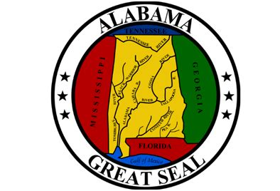

Alabama – This state is the cotton state of the USA and its name comes from the Indian, derived from the tribes of the Alabamos or Alibamos once settled here. Alabama is also called Heart of the South (Heart of Dixie). Alabama has approximately 3.6 million inhabitants, the capital is Montgomery. The state was discovered in 1540 by the Spaniard Hernando de Soto, but it was not until 1702 that the French settled near Mobile Bay. Alabama was originally part of the vast Mississippi Territory. In 1819 Alabama became the 22nd state in the United States. The main products of this country are cotton, steel and peanuts. The most famous citizens are Nat King Cole and Olympic champion Jesse Owens (4 gold medals in Berlin in 1936). Alabama is also known for its racial riots that have flared up particularly in the past.
| Rank | Name | County | 2021 Pop. | Density (mi²) | Area (mi²) |
|---|---|---|---|---|---|
| 1 | Birmingham | Jefferson County | 207,235 | 1,419 | 146.08 |
| 2 | Huntsville | Madison County | 205,472 | 959 | 214.36 |
| 3 | Montgomery | Montgomery County | 197,777 | 1,237 | 159.88 |
| 4 | Mobile | Mobile County | 186,542 | 1,338 | 139.47 |
| 5 | Tuscaloosa | Tuscaloosa County | 103,007 | 1,665 | 61.85 |
| 6 | Hoover | Shelby County | 86,270 | 1,802 | 47.89 |
| 7 | Dothan | Houston County | 70,149 | 782 | 89.76 |
| 8 | Auburn | Lee County | 67,787 | 1,128 | 60.08 |
| 9 | Decatur | Morgan County | 54,607 | 1,008 | 54.16 |
| 10 | Madison | Limestone County | 53,797 | 1,774 | 30.32 |
| 11 | Florence | Lauderdale County | 40,993 | 1,548 | 26.48 |
| 12 | Phenix City | Russell County | 36,617 | 1,308 | 28 |
| 13 | Prattville | Autauga County | 36,587 | 1,081 | 33.86 |
| 14 | Gadsden | Etowah County | 34,490 | 924 | 37.31 |
| 15 | Vestavia Hills | Jefferson County | 34,351 | 1,729 | 19.87 |
| 16 | Alabaster | Shelby County | 33,635 | 1,332 | 25.25 |
| 17 | Opelika | Lee County | 31,472 | 533 | 59.07 |
| 18 | Athens | Limestone County | 29,216 | 733 | 39.86 |
| 19 | Enterprise | Coffee County | 28,830 | 941 | 30.63 |
| 20 | Daphne | Baldwin County | 27,599 | 1,606 | 17.18 |
| 21 | Bessemer | Jefferson County | 26,250 | 648 | 40.54 |
| 22 | Northport | Tuscaloosa County | 26,249 | 1,554 | 16.89 |
| 23 | Homewood | Jefferson County | 25,199 | 3,021 | 8.34 |
| 24 | Pelham | Shelby County | 24,343 | 627 | 38.82 |
| 25 | Fairhope | Baldwin County | 23,901 | 1,709 | 13.99 |
| 26 | Trussville | Jefferson County | 23,563 | 686 | 34.35 |
| 27 | Foley | Baldwin County | 23,379 | 720 | 32.48 |
| 28 | Albertville | Marshall County | 21,975 | 821 | 26.78 |
| 29 | Prichard | Mobile County | 21,136 | 835 | 25.31 |
| 30 | Oxford | Calhoun County | 21,075 | 663 | 31.77 |
| 31 | Anniston | Calhoun County | 20,835 | 455 | 45.76 |
| 32 | Helena | Shelby County | 20,633 | 1,013 | 20.38 |
| 33 | Mountain Brook | 20,145 | 1,571 | 12.82 | |
| 34 | Troy | Pike County | 18,829 | 664 | 28.34 |
| 35 | Tillmans Corner | 17,560 | 1,354 | 12.97 | |
| 36 | Cullman | Cullman County | 16,334 | 748 | 21.84 |
| 37 | Selma | Dallas County | 16,095 | 1,166 | 13.81 |
| 38 | Millbrook | Elmore County | 16,040 | 1,144 | 14.02 |
| 39 | Center Point | 15,876 | 2,567 | 6.18 | |
| 40 | Calera | Shelby County | 15,547 | 643 | 24.17 |
| 41 | Talladega | Talladega County | 15,341 | 601 | 25.5 |
| 42 | Chelsea | Shelby County | 15,314 | 663 | 23.08 |
| 43 | Hueytown | 15,128 | 769 | 19.68 | |
| 44 | Muscle Shoals | Colbert County | 15,087 | 912 | 16.54 |
| 45 | Saraland | Mobile County | 14,711 | 459 | 32.06 |
| 46 | Hartselle | Morgan County | 14,546 | 885 | 16.44 |
| 47 | Scottsboro | Jackson County | 14,436 | 285 | 50.66 |
| 48 | Pell City | St Clair County | 14,431 | 580 | 24.88 |
| 49 | Gardendale | Jefferson County | 14,333 | 626 | 22.89 |
| 50 | Ozark | Dale County | 14,194 | 416 | 34.09 |
| 51 | Alexander City | Tallapoosa County | 14,047 | 334 | 42 |
| 52 | Fort Payne | Dekalb County | 14,024 | 250 | 56.19 |
| 53 | Irondale | 13,353 | 771 | 17.32 | |
| 54 | Jasper | Walker County | 13,275 | 457 | 29.06 |
| 55 | Moody | St Clair County | 13,267 | 541 | 24.53 |
| 56 | Gulf Shores | Baldwin County | 13,203 | 469 | 28.18 |
| 57 | Jacksonville | Calhoun County | 12,376 | 1,134 | 10.91 |
| 58 | Leeds | Jefferson County | 12,020 | 535 | 22.48 |
| 59 | Sylacauga | Talladega County | 11,866 | 586 | 20.25 |
| 60 | Eufaula | Barbour County | 11,459 | 193 | 59.52 |
| 61 | Pike Road | Montgomery County | 10,841 | 330 | 32.84 |
| 62 | Saks | 10,645 | 874 | 12.18 | |
| 63 | Fairfield | Jefferson County | 10,414 | 3,001 | 3.47 |
| 64 | Clay | Jefferson County | 9,997 | 995 | 10.04 |
| 65 | Russellville | Franklin County | 9,771 | 728 | 13.43 |
| 66 | Boaz | Marshall County | 9,756 | 671 | 14.55 |
| 67 | Spanish Fort | Baldwin County | 9,732 | 322 | 30.23 |
| 68 | Rainbow City | Etowah County | 9,639 | 380 | 25.36 |
| 69 | Pleasant Grove | Jefferson County | 9,566 | 968 | 9.88 |
| 70 | Bay Minette | Baldwin County | 9,516 | 552 | 17.25 |
| 71 | Meadowbrook | 9,468 | 2,206 | 4.29 | |
| 72 | Fultondale | Jefferson County | 9,394 | 770 | 12.2 |
| 73 | Atmore | Escambia County | 9,129 | 418 | 21.86 |
| 74 | Clanton | Chilton County | 9,034 | 395 | 22.84 |
| 75 | Southside | 9,001 | 474 | 18.97 | |
| 76 | Valley | Chambers County | 8,943 | 699 | 12.79 |
| 77 | Forestdale | 8,924 | 1,322 | 6.75 | |
| 78 | Sheffield | Colbert County | 8,819 | 1,268 | 6.95 |
| 79 | Guntersville | Marshall County | 8,685 | 339 | 25.64 |
| 80 | Andalusia | Covington County | 8,668 | 441 | 19.66 |
| 81 | Tuscumbia | Colbert County | 8,485 | 920 | 9.22 |
| 82 | Arab | Marshall County | 8,469 | 636 | 13.32 |
| 83 | Wetumpka | Elmore County | 8,429 | 771 | 10.94 |
| 84 | Tuskegee | Macon County | 7,896 | 490 | 16.11 |
| 85 | Greenville | Butler County | 7,219 | 338 | 21.35 |
| 86 | Brook Highland | 7,147 | 2,547 | 2.81 | |
| 87 | Robertsdale | Baldwin County | 7,133 | 1,051 | 6.78 |
| 88 | Meridianville | Madison County | 7,087 | 456 | 15.56 |
| 89 | Pinson | Jefferson County | 7,086 | 666 | 10.64 |
| 90 | Montevallo | Shelby County | 6,902 | 539 | 12.81 |
| 91 | Lincoln | Talladega County | 6,891 | 275 | 25.1 |
| 92 | Moores Mill | 6,882 | 506 | 13.61 | |
| 93 | Hamilton | Marion County | 6,582 | 173 | 38.06 |
| 94 | Oneonta | Blount County | 6,545 | 416 | 15.75 |
| 95 | Orange Beach | Baldwin County | 6,483 | 441 | 14.71 |
| 96 | Demopolis | Marengo County | 6,438 | 363 | 17.74 |
| 97 | Opp | Covington County | 6,392 | 270 | 23.66 |
| 98 | Theodore | Mobile County | 6,334 | 792 | 7.99 |
| 99 | Satsuma | Mobile County | 6,238 | 851 | 7.33 |
| 100 | Grayson Valley | 6,209 | 3,169 | 1.96 | |
| 101 | Tarrant | 6,011 | 942 | 6.38 | |
| 102 | Lanett | Chambers County | 5,975 | 957 | 6.24 |
| 103 | Roanoke | Randolph County | 5,875 | 314 | 18.74 |
| 104 | Harvest | Madison County | 5,819 | 472 | 12.33 |
| 105 | Semmes | Mobile County | 5,810 | 476 | 12.21 |
| 106 | Attalla | Etowah County | 5,705 | 817 | 6.98 |
| 107 | Chickasaw | 5,608 | 1,333 | 4.21 | |
| 108 | Margaret | St Clair County | 5,539 | 564 | 9.82 |
| 109 | Highland Lakes | 5,519 | 1,469 | 3.76 | |
| 110 | Monroeville | Monroe County | 5,508 | 412 | 13.35 |
| 111 | Smiths Station | Lee County | 5,345 | 773 | 6.92 |
| 112 | Rainsville | Dekalb County | 5,313 | 258 | 20.62 |
| 113 | Fort Rucker | Dale County | 5,311 | 489 | 10.86 |
| 114 | Brewton | Escambia County | 5,220 | 465 | 11.22 |
| 115 | Daleville | Dale County | 5,114 | 362 | 14.14 |
| 116 | Glencoe | 5,017 | 298 | 16.85 | |
| 117 | Midfield | 4,914 | 1,852 | 2.65 | |
| 118 | Childersburg | Talladega County | 4,775 | 387 | 12.33 |
| 119 | Headland | Henry County | 4,768 | 157 | 30.33 |
| 120 | Brent | Bibb County | 4,739 | 540 | 8.78 |
| 121 | Columbiana | Shelby County | 4,546 | 263 | 17.3 |
| 122 | Jackson | Clarke County | 4,498 | 288 | 15.64 |
| 123 | Pine Level | Montgomery County | 4,484 | 181 | 24.81 |
| 124 | Winfield | Marion County | 4,469 | 251 | 17.78 |
| 125 | Holtville | 4,449 | 206 | 21.58 | |
| 126 | Tallassee | Elmore County | 4,446 | 402 | 11.06 |
| 127 | Piedmont | Calhoun County | 4,445 | 452 | 9.82 |
| 128 | Argo | 4,406 | 410 | 10.75 | |
| 129 | Redland | 4,388 | 182 | 24.13 | |
| 130 | Mount Olive | Jefferson County | 4,387 | 476 | 9.22 |
| 131 | Springville | St Clair County | 4,358 | 490 | 8.89 |
| 132 | Geneva | Geneva County | 4,253 | 268 | 15.88 |
| 133 | Hokes Bluff | 4,229 | 355 | 11.93 | |
| 134 | Adamsville | Jefferson County | 4,227 | 168 | 25.17 |
| 135 | Fayette | Fayette County | 4,175 | 488 | 8.55 |
| 136 | Haleyville | Winston County | 4,098 | 489 | 8.38 |
| 137 | Priceville | 4,098 | 703 | 5.83 | |
| 138 | Alexandria | Calhoun County | 4,068 | 365 | 11.13 |
| 139 | Holt | 3,952 | 1,249 | 3.16 | |
| 140 | Odenville | St Clair County | 3,933 | 277 | 14.19 |
| 141 | Hazel Green | Madison County | 3,901 | 389 | 10.03 |
| 142 | Grand Bay | Mobile County | 3,897 | 449 | 8.68 |
| 143 | Citronelle | Mobile County | 3,831 | 148 | 25.85 |
| 144 | Elba | Coffee County | 3,825 | 249 | 15.34 |
| 145 | Thomasville | Clarke County | 3,736 | 428 | 8.73 |
| 146 | Loxley | Baldwin County | 3,653 | 115 | 31.86 |
| 147 | Kimberly | Jefferson County | 3,621 | 605 | 5.98 |
| 148 | Centre | Cherokee County | 3,570 | 317 | 11.24 |
| 149 | Hanceville | Cullman County | 3,551 | 789 | 4.5 |
| 150 | Emerald Mountain | 3,472 | 216 | 16.09 | |
| 151 | Valley Grande | 3,412 | 102 | 33.51 | |
| 152 | Ladonia | 3,391 | 1,082 | 3.13 | |
| 153 | Evergreen | Conecuh County | 3,372 | 171 | 19.75 |
| 154 | Heflin | Cleburne County | 3,349 | 208 | 16.09 |
| 155 | Union Springs | Bullock County | 3,326 | 502 | 6.63 |
| 156 | West End-Cobb Town | 3,274 | 795 | 4.12 | |
| 157 | Warrior | Jefferson County | 3,242 | 332 | 9.75 |
| 158 | Moulton | Lawrence County | 3,215 | 536 | 5.99 |
| 159 | Underwood-Petersville | 3,170 | 547 | 5.8 | |
| 160 | Livingston | Sumter County | 3,166 | 444 | 7.13 |
| 161 | Cottondale | Tuscaloosa County | 3,136 | 907 | 3.46 |
| 162 | Red Bay | Franklin County | 3,089 | 317 | 9.75 |
| 163 | Marion | Perry County | 3,025 | 286 | 10.57 |
| 164 | Weaver | Calhoun County | 3,025 | 870 | 3.48 |
| 165 | Lake View | 3,017 | 1,435 | 2.1 | |
| 166 | Choccolocco | Calhoun County | 3,011 | 259 | 11.64 |
| 167 | Dadeville | Tallapoosa County | 2,997 | 188 | 15.94 |
| 168 | New Hope | Madison County | 2,970 | 343 | 8.66 |
| 169 | La Fayette | 2,850 | 322 | 8.86 | |
| 170 | Clayton | Barbour County | 2,819 | 417 | 6.76 |
| 171 | Brighton | 2,735 | 1,933 | 1.42 | |
| 172 | Jemison | Chilton County | 2,728 | 240 | 11.35 |
| 173 | Luverne | Crenshaw County | 2,714 | 173 | 15.65 |
| 174 | Point Clear | Baldwin County | 2,652 | 553 | 4.8 |
| 175 | Whitesboro | 2,602 | 149 | 17.48 | |
| 176 | Hartford | Geneva County | 2,588 | 415 | 6.24 |
| 177 | Huguley | 2,583 | 312 | 8.27 | |
| 178 | Centreville | Bibb County | 2,581 | 273 | 9.45 |
| 179 | Carlisle-Rockledge | 2,577 | 159 | 16.19 | |
| 180 | Indian Springs Village | 2,559 | 661 | 3.87 | |
| 181 | Abbeville | Henry County | 2,538 | 163 | 15.54 |
| 182 | Eutaw | Greene County | 2,535 | 212 | 11.93 |
| 183 | Moundville | Hale County | 2,509 | 544 | 4.61 |
| 184 | Trinity | Lawrence County | 2,509 | 508 | 4.94 |
| 185 | Taylor | 2,478 | 343 | 7.23 | |
| 186 | Bayou La Batre | Mobile County | 2,453 | 326 | 7.52 |
| 187 | Ashville | St Clair County | 2,405 | 125 | 19.21 |
| 188 | Riverside | St Clair County | 2,401 | 277 | 8.66 |
| 189 | Good Hope | 2,386 | 302 | 7.91 | |
| 190 | Midland City | Dale County | 2,382 | 393 | 6.05 |
| 191 | Owens Cross Roads | Madison County | 2,371 | 286 | 8.28 |
| 192 | Kinsey | 2,365 | 195 | 12.12 | |
| 193 | East Brewton | 2,360 | 692 | 3.41 | |
| 194 | Henagar | Dekalb County | 2,357 | 106 | 22.27 |
| 195 | Sumiton | Walker County | 2,314 | 444 | 5.21 |
| 196 | Bridgeport | Jackson County | 2,281 | 527 | 4.33 |
| 197 | Guin | Marion County | 2,253 | 150 | 14.97 |
| 198 | Lineville | Clay County | 2,225 | 230 | 9.67 |
| 199 | Vincent | Shelby County | 2,223 | 108 | 20.58 |
| 200 | Ashford | Houston County | 2,221 | 358 | 6.2 |
| 201 | Morris | Jefferson County | 2,211 | 720 | 3.07 |
| 202 | Greensboro | Hale County | 2,210 | 930 | 2.38 |
| 203 | Aliceville | Pickens County | 2,204 | 483 | 4.56 |
| 204 | York | Sumter County | 2,157 | 314 | 6.87 |
| 205 | Uniontown | Perry County | 2,145 | 141 | 15.18 |
| 206 | Cowarts | Houston County | 2,127 | 286 | 7.43 |
| 207 | Lipscomb | 2,121 | 1,807 | 1.17 | |
| 208 | Smoke Rise | 2,101 | 363 | 5.79 | |
| 209 | Thorsby | Chilton County | 2,077 | 356 | 5.83 |
| 210 | Creola | Mobile County | 2,076 | 146 | 14.24 |
| 211 | Wilsonville | Shelby County | 2,064 | 197 | 10.49 |
| 212 | Graysville | Jefferson County | 2,062 | 121 | 17.01 |
| 213 | Summerdale | Baldwin County | 2,041 | 201 | 10.13 |
| 214 | Collinsville | Dekalb County | 2,017 | 515 | 3.92 |
| 215 | Level Plains | 1,998 | 651 | 3.07 | |
| 216 | Stevenson | Jackson County | 1,943 | 253 | 7.7 |
| 217 | Florala | Covington County | 1,916 | 182 | 10.53 |
| 218 | Sylvania | Dekalb County | 1,898 | 215 | 8.82 |
| 219 | Slocomb | Geneva County | 1,886 | 199 | 9.49 |
| 220 | Dora | Jefferson County | 1,885 | 251 | 7.51 |
| 221 | Lookout Mountain | 1,884 | 124 | 15.23 | |
| 222 | Carbon Hill | Walker County | 1,872 | 340 | 5.5 |
| 223 | Ashland | Clay County | 1,867 | 255 | 7.33 |
| 224 | Brundidge | Pike County | 1,862 | 191 | 9.75 |
| 225 | Cedar Bluff | Cherokee County | 1,851 | 379 | 4.88 |
| 226 | Crossville | Dekalb County | 1,851 | 221 | 8.37 |
| 227 | Linden | Marengo County | 1,842 | 515 | 3.58 |
| 228 | Brookwood | Tuscaloosa County | 1,840 | 220 | 8.37 |
| 229 | Samson | Geneva County | 1,834 | 507 | 3.62 |
| 230 | Rehobeth | 1,827 | 244 | 7.49 | |
| 231 | Cordova | Walker County | 1,826 | 313 | 5.83 |
| 232 | Vernon | Lamar County | 1,818 | 308 | 5.89 |
| 233 | Sulligent | Lamar County | 1,816 | 232 | 7.83 |
| 234 | Selmont-West Selmont | 1,812 | 553 | 3.28 | |
| 235 | Elberta | Baldwin County | 1,794 | 257 | 6.98 |
| 236 | Sardis City | 1,753 | 223 | 7.86 | |
| 237 | Westover | Shelby County | 1,750 | 90 | 19.43 |
| 238 | Ragland | St Clair County | 1,738 | 104 | 16.79 |
| 239 | Harpersville | Shelby County | 1,729 | 81 | 21.29 |
| 240 | Lillian | Baldwin County | 1,728 | 905 | 1.91 |
| 241 | Vance | Tuscaloosa County | 1,704 | 167 | 10.18 |
| 242 | Woodstock | Bibb County | 1,702 | 241 | 7.08 |
| 243 | Blountsville | Blount County | 1,680 | 310 | 5.42 |
| 244 | Grove Hill | Clarke County | 1,680 | 221 | 7.59 |
| 245 | Camden | Wilcox County | 1,679 | 401 | 4.18 |
| 246 | Coaling | Tuscaloosa County | 1,649 | 329 | 5.01 |
| 247 | Butler | Choctaw County | 1,639 | 243 | 6.75 |
| 248 | Stewartville | 1,634 | 68 | 24.14 | |
| 249 | Marbury | Autauga County | 1,633 | 71 | 23.15 |
| 250 | Concord | 1,616 | 480 | 3.37 | |
| 251 | Triana | 1,607 | 1,313 | 1.22 | |
| 252 | Ballplay | 1,605 | 68 | 23.55 | |
| 253 | Gordo | Pickens County | 1,592 | 489 | 3.25 |
| 254 | Georgiana | Butler County | 1,574 | 252 | 6.24 |
| 255 | Ardmore | Limestone County | 1,539 | 754 | 2.04 |
| 256 | Reform | Pickens County | 1,520 | 190 | 8.01 |
| 257 | Silverhill | Baldwin County | 1,520 | 1,210 | 1.26 |
| 258 | Webb | Houston County | 1,519 | 135 | 11.26 |
| 259 | Rock Creek | 1,508 | 500 | 3.02 | |
| 260 | Mount Vernon | Mobile County | 1,507 | 275 | 5.48 |
| 261 | Blue Ridge | 1,490 | 192 | 7.76 | |
| 262 | Sylvan Springs | 1,476 | 170 | 8.69 | |
| 263 | Malvern | Geneva County | 1,471 | 105 | 14.02 |
| 264 | Newton | Dale County | 1,468 | 103 | 14.25 |
| 265 | Stapleton | Baldwin County | 1,421 | 130 | 10.91 |
| 266 | Dauphin Island | Mobile County | 1,411 | 226 | 6.26 |
| 267 | Flomaton | Escambia County | 1,401 | 275 | 5.09 |
| 268 | Elmore | Elmore County | 1,388 | 221 | 6.27 |
| 269 | Fayetteville | 1,378 | 79 | 17.44 | |
| 270 | Shoal Creek | 1,376 | 274 | 5.02 | |
| 271 | Coats Bend | 1,358 | 159 | 8.55 | |
| 272 | New Brockton | Coffee County | 1,349 | 169 | 7.99 |
| 273 | Hayden | Blount County | 1,347 | 336 | 4.01 |
| 274 | Munford | Talladega County | 1,344 | 525 | 2.56 |
| 275 | Redstone Arsenal | 1,329 | 172 | 7.71 | |
| 276 | Brookside | Jefferson County | 1,313 | 205 | 6.4 |
| 277 | Goodwater | Coosa County | 1,313 | 202 | 6.49 |
| 278 | Cleveland | Blount County | 1,304 | 167 | 7.83 |
| 279 | Coosada | Elmore County | 1,304 | 189 | 6.89 |
| 280 | Rogersville | Lauderdale County | 1,287 | 424 | 3.03 |
| 281 | Cottonwood | Houston County | 1,265 | 219 | 5.78 |
| 282 | Falkville | Morgan County | 1,259 | 333 | 3.78 |
| 283 | Hackleburg | Marion County | 1,258 | 82 | 15.28 |
| 284 | Clio | Barbour County | 1,254 | 125 | 10.07 |
| 285 | West Blocton | Bibb County | 1,252 | 261 | 4.8 |
| 286 | Deatsville | Elmore County | 1,239 | 257 | 4.81 |
| 287 | Bon Secour | Baldwin County | 1,234 | 286 | 4.32 |
| 288 | Tidmore Bend | 1,221 | 127 | 9.63 | |
| 289 | Locust Fork | Blount County | 1,201 | 311 | 3.86 |
| 290 | Axis | Mobile County | 1,180 | 303 | 3.9 |
| 291 | Chatom | Washington County | 1,166 | 109 | 10.72 |
| 292 | Ohatchee | Calhoun County | 1,161 | 198 | 5.88 |
| 293 | New Market | Madison County | 1,122 | 64 | 17.53 |
| 294 | Frisco City | Monroe County | 1,111 | 276 | 4.03 |
| 295 | Steele | St Clair County | 1,099 | 164 | 6.71 |
| 296 | Fort Deposit | Lowndes County | 1,093 | 193 | 5.66 |
| 297 | Berry | Fayette County | 1,083 | 101 | 10.77 |
| 298 | Fyffe | Dekalb County | 1,081 | 245 | 4.41 |
| 299 | Bear Creek | Marion County | 1,068 | 78 | 13.63 |
| 300 | Phil Campbell | Franklin County | 1,067 | 263 | 4.06 |
| 301 | Double Springs | Winston County | 1,052 | 206 | 5.12 |
| 302 | Egypt | 1,034 | 115 | 9.01 | |
| 303 | Town Creek | Lawrence County | 1,029 | 384 | 2.68 |
| 304 | Leesburg | Cherokee County | 1,027 | 164 | 6.27 |
| 305 | Eclectic | Elmore County | 1,021 | 249 | 4.11 |
| 306 | Hollywood | Jackson County | 1,004 | 113 | 8.92 |
| 307 | Cherokee | Colbert County | 1,002 | 452 | 2.22 |
| 308 | Littleville | 994 | 200 | 4.97 | |
| 309 | Sterrett | Shelby County | 977 | 43 | 22.93 |
| 310 | Powell | 967 | 195 | 4.96 | |
| 311 | Leroy | Washington County | 964 | 81 | 11.91 |
| 312 | Millport | Lamar County | 964 | 175 | 5.49 |
| 313 | Dunnavant | 957 | 53 | 18.05 | |
| 314 | Coker | Tuscaloosa County | 954 | 489 | 1.95 |
| 315 | Killen | Lauderdale County | 951 | 470 | 2.02 |
| 316 | Vandiver | Shelby County | 949 | 46 | 20.47 |
| 317 | Parrish | Walker County | 935 | 447 | 2.09 |
| 318 | Camp Hill | Tallapoosa County | 932 | 104 | 8.99 |
| 319 | Carrollton | Pickens County | 925 | 449 | 2.06 |
| 320 | Grant | Marshall County | 924 | 499 | 1.85 |
| 321 | Altoona | Etowah County | 905 | 209 | 4.32 |
| 322 | Geraldine | Dekalb County | 894 | 228 | 3.92 |
| 323 | Ivalee | 887 | 119 | 7.45 | |
| 324 | Shelby | Shelby County | 885 | 47 | 18.76 |
| 325 | Autaugaville | Autauga County | 873 | 111 | 7.83 |
| 326 | Brilliant | Marion County | 871 | 82 | 10.59 |
| 327 | Brantleyville | 860 | 392 | 2.2 | |
| 328 | Mignon | 850 | 425 | 2 | |
| 329 | White Plains | 850 | 66 | 12.79 | |
| 330 | Minor | 843 | 1,203 | 0.7 | |
| 331 | Skyline | 842 | 212 | 3.98 | |
| 332 | Magnolia Springs | Baldwin County | 839 | 933 | 0.9 |
| 333 | Snead | 834 | 151 | 5.52 | |
| 334 | Gallant | Etowah County | 833 | 58 | 14.38 |
| 335 | New Union | 829 | 68 | 12.18 | |
| 336 | Jacksons’ Gap | 827 | 97 | 8.52 | |
| 337 | Mosses | 826 | 174 | 4.74 | |
| 338 | Holly Pond | Cullman County | 824 | 186 | 4.44 |
| 339 | Pine Hill | Wilcox County | 812 | 213 | 3.82 |
| 340 | Gurley | Madison County | 810 | 228 | 3.55 |
| 341 | Mulga | Jefferson County | 804 | 1,252 | 0.64 |
| 342 | Hollins | Clay County | 797 | 67 | 11.85 |
| 343 | Notasulga | Macon County | 797 | 58 | 13.8 |
| 344 | Perdido | Baldwin County | 795 | 71 | 11.14 |
| 345 | Wedowee | Randolph County | 788 | 226 | 3.49 |
| 346 | Douglas | Marshall County | 784 | 230 | 3.4 |
| 347 | Somerville | Morgan County | 781 | 255 | 3.06 |
| 348 | Susan Moore | 778 | 149 | 5.23 | |
| 349 | New Site | 758 | 77 | 9.87 | |
| 350 | Brantley | Crenshaw County | 756 | 243 | 3.11 |
| 351 | Leighton | Colbert County | 754 | 350 | 2.16 |
| 352 | Columbia | Henry County | 749 | 191 | 3.93 |
| 353 | South Vinemont | 749 | 860 | 0.87 | |
| 354 | Ariton | Dale County | 741 | 146 | 5.09 |
| 355 | Section | Jackson County | 740 | 162 | 4.57 |
| 356 | Edgewater | 739 | 609 | 1.21 | |
| 357 | Hobson City | 739 | 707 | 1.05 | |
| 358 | Hayneville | Lowndes County | 738 | 397 | 1.86 |
| 359 | Woodville | Jackson County | 719 | 109 | 6.62 |
| 360 | Ider | Dekalb County | 714 | 131 | 5.43 |
| 361 | Oakman | Walker County | 714 | 232 | 3.08 |
| 362 | White Hall | 713 | 47 | 15.3 | |
| 363 | St. Florian | 712 | 188 | 3.78 | |
| 364 | Wadley | Randolph County | 712 | 489 | 1.46 |
| 365 | Lexington | Lauderdale County | 709 | 219 | 3.24 |
| 366 | Addison | Winston County | 708 | 188 | 3.77 |
| 367 | Maplesville | Chilton County | 702 | 215 | 3.27 |
| 368 | Walnut Grove | Etowah County | 702 | 140 | 5.03 |
| 369 | Pisgah | Jackson County | 694 | 145 | 4.8 |
| 370 | Our Town | 688 | 58 | 11.88 | |
| 371 | Hollis Crossroads | 679 | 55 | 12.46 | |
| 372 | Wilton | Chilton County | 677 | 707 | 0.96 |
| 373 | Perdido Beach | 669 | 565 | 1.19 | |
| 374 | Bristow Cove | 668 | 62 | 10.84 | |
| 375 | Joppa | Cullman County | 664 | 342 | 1.94 |
| 376 | Allgood | Blount County | 658 | 633 | 1.04 |
| 377 | Lynn | Winston County | 633 | 59 | 10.65 |
| 378 | Pinckard | Dale County | 632 | 119 | 5.33 |
| 379 | Dodge City | 627 | 182 | 3.44 | |
| 380 | Stockton | Baldwin County | 626 | 67 | 9.34 |
| 381 | Baileyton | Cullman County | 623 | 119 | 5.25 |
| 382 | North Courtland | 622 | 940 | 0.66 | |
| 383 | Reece City | 621 | 175 | 3.56 | |
| 384 | West Point | 613 | 180 | 3.41 | |
| 385 | Trafford | Blount County | 611 | 251 | 2.44 |
| 386 | Calvert | Washington County | 609 | 260 | 2.34 |
| 387 | Excel | Monroe County | 606 | 368 | 1.65 |
| 388 | Babbie | 600 | 52 | 11.47 | |
| 389 | Clayhatchee | 589 | 217 | 2.72 | |
| 390 | Hurtsboro | Russell County | 589 | 570 | 1.03 |
| 391 | Courtland | Lawrence County | 586 | 199 | 2.95 |
| 392 | Forkland | Greene County | 574 | 164 | 3.49 |
| 393 | McDonald Chapel | 573 | 534 | 1.07 | |
| 394 | Pickensville | 572 | 74 | 7.73 | |
| 395 | Sand Rock | 569 | 137 | 4.14 | |
| 396 | Belle Fontaine | 564 | 363 | 1.55 | |
| 397 | Grimes | 562 | 450 | 1.25 | |
| 398 | Kinston | Coffee County | 551 | 113 | 4.89 |
| 399 | Valley Head | Dekalb County | 547 | 158 | 3.47 |
| 400 | River Falls | Covington County | 545 | 80 | 6.83 |
| 401 | Elkmont | Limestone County | 532 | 324 | 1.64 |
| 402 | Avon | 530 | 205 | 2.58 | |
| 403 | Oak Grove | 521 | 293 | 1.78 | |
| 404 | Castleberry | Conecuh County | 520 | 304 | 1.71 |
| 405 | Hillsboro | Lawrence County | 519 | 276 | 1.88 |
| 406 | Lockhart | Covington County | 510 | 469 | 1.09 |
| 407 | Newville | Henry County | 510 | 127 | 4.02 |
| 408 | Eva | Morgan County | 499 | 120 | 4.15 |
| 409 | Garden City | Cullman County | 499 | 166 | 3.01 |
| 410 | Hammondville | 497 | 101 | 4.9 | |
| 411 | Millry | Washington County | 493 | 66 | 7.49 |
| 412 | Rock Mills | 493 | 78 | 6.33 | |
| 413 | Franklin | Monroe County | 492 | 33 | 15.09 |
| 414 | McKenzie | 484 | 130 | 3.72 | |
| 415 | Red Level | Covington County | 484 | 252 | 1.92 |
| 416 | Nances Creek | 476 | 82 | 5.81 | |
| 417 | Lisman | Choctaw County | 475 | 184 | 2.59 |
| 418 | Glen Allen | Fayette County | 470 | 72 | 6.53 |
| 419 | Bellamy | Sumter County | 466 | 123 | 3.78 |
| 420 | Fairview | 463 | 171 | 2.71 | |
| 421 | Midway | Bullock County | 460 | 139 | 3.31 |
| 422 | Louisville | Barbour County | 456 | 166 | 2.75 |
| 423 | Berlin | 454 | 548 | 0.83 | |
| 424 | St. Stephens | 441 | 45 | 9.88 | |
| 425 | Rutledge | Crenshaw County | 439 | 75 | 5.86 |
| 426 | Rockford | Coosa County | 430 | 130 | 3.31 |
| 427 | Hytop | 420 | 121 | 3.46 | |
| 428 | West Jefferson | 417 | 232 | 1.8 | |
| 429 | Hackneyville | 416 | 46 | 8.96 | |
| 430 | Hissop | 415 | 23 | 18.26 | |
| 431 | Kennedy | Lamar County | 415 | 135 | 3.07 |
| 432 | Silas | Choctaw County | 414 | 80 | 5.21 |
| 433 | Highland Lake | 408 | 250 | 1.63 | |
| 434 | Pleasant Groves | 402 | 110 | 3.65 | |
| 435 | Sipsey | Walker County | 401 | 834 | 0.48 |
| 436 | Ranburne | Cleburne County | 394 | 248 | 1.59 |
| 437 | Twin | 394 | 117 | 3.38 | |
| 438 | Shorter | Macon County | 383 | 84 | 4.54 |
| 439 | Vinegar Bend | Washington County | 383 | 41 | 9.45 |
| 440 | Thomaston | Marengo County | 373 | 185 | 2.01 |
| 441 | Mentone | Dekalb County | 370 | 79 | 4.67 |
| 442 | Maytown | 367 | 137 | 2.68 | |
| 443 | Mount Olive | Jefferson County | 358 | 43 | 8.32 |
| 444 | Vina | Franklin County | 356 | 74 | 4.8 |
| 445 | Malcolm | Washington County | 354 | 150 | 2.36 |
| 446 | Arley | Winston County | 345 | 92 | 3.76 |
| 447 | Napier Field | 342 | 1,336 | 0.26 | |
| 448 | Nectar | 339 | 187 | 1.81 | |
| 449 | Gordon | Houston County | 327 | 112 | 2.92 |
| 450 | Rosa | 323 | 86 | 3.77 | |
| 451 | Akron | Hale County | 322 | 469 | 0.69 |
| 452 | Uriah | Monroe County | 318 | 198 | 1.61 |
| 453 | Dozier | Crenshaw County | 316 | 107 | 2.95 |
| 454 | Epes | Sumter County | 315 | 48 | 6.59 |
| 455 | Coffeeville | Clarke County | 314 | 69 | 4.52 |
| 456 | Dutton | Jackson County | 312 | 361 | 0.86 |
| 457 | Ray | 300 | 37 | 8.2 | |
| 458 | Weogufka | Coosa County | 299 | 36 | 8.26 |
| 459 | Carolina | 297 | 268 | 1.11 | |
| 460 | Colony | 293 | 130 | 2.25 | |
| 461 | Madrid | 292 | 167 | 1.75 | |
| 462 | Pine Ridge | 288 | 222 | 1.3 | |
| 463 | Vredenburgh | Monroe County | 284 | 189 | 1.5 |
| 464 | Hodges | Franklin County | 283 | 69 | 4.13 |
| 465 | Shiloh | 283 | 165 | 1.71 | |
| 466 | Delta | Clay County | 282 | 36 | 7.79 |
| 467 | Whatley | Clarke County | 280 | 217 | 1.29 |
| 468 | Fruithurst | Cleburne County | 278 | 278 | 1 |
| 469 | Boligee | Greene County | 274 | 69 | 3.95 |
| 470 | Cuba | Sumter County | 274 | 67 | 4.06 |
| 471 | Reeltown | 274 | 36 | 7.55 | |
| 472 | County Line | 273 | 283 | 0.96 | |
| 473 | Beatrice | Monroe County | 272 | 201 | 1.35 |
| 474 | Waldo | 272 | 97 | 2.81 | |
| 475 | Boykin | Wilcox County | 269 | 101 | 2.66 |
| 476 | Anderson | Lauderdale County | 265 | 205 | 1.29 |
| 477 | Gordonville | 262 | 47 | 5.54 | |
| 478 | Heath | 260 | 292 | 0.89 | |
| 479 | Langston | Marshall County | 260 | 53 | 4.92 |
| 480 | East Point | 259 | 270 | 0.96 | |
| 481 | Gulfcrest | 259 | 171 | 1.51 | |
| 482 | Goshen | Pike County | 255 | 100 | 2.56 |
| 483 | Morrison Crossroads | 254 | 49 | 5.19 | |
| 484 | Sanford | 254 | 61 | 4.18 | |
| 485 | Bakerhill | 250 | 91 | 2.75 | |
| 486 | Ren | 246 | 257 | 0.96 | |
| 487 | Fulton | Clarke County | 238 | 97 | 2.45 |
| 488 | Sweet Water | Marengo County | 238 | 101 | 2.35 |
| 489 | Cullomburg | 229 | 43 | 5.34 | |
| 490 | Fredonia | 229 | 19 | 11.98 | |
| 491 | Horn Hill | 229 | 90 | 2.56 | |
| 492 | Chunchula | Mobile County | 220 | 122 | 1.8 |
| 493 | Detroit | Lamar County | 216 | 163 | 1.33 |
| 494 | Gantt | Covington County | 215 | 331 | 0.65 |
| 495 | Coffee Springs | Geneva County | 212 | 270 | 0.78 |
| 496 | McIntosh | 211 | 212 | 1 | |
| 497 | Daviston | Tallapoosa County | 210 | 23 | 9.13 |
| 498 | Kansas | Walker County | 209 | 206 | 1.02 |
| 499 | Black | Geneva County | 201 | 65 | 3.08 |
| 500 | Paint Rock | Jackson County | 201 | 464 | 0.43 |
Alabama Population
Alabama is the 30th most populous state in the United States, with an estimated population of 4.9…
Alabama
Birmingham
Population: Birmingham, Alabama’s largest city, is home to over 200,000 residents.
Area: The city spans approximately 146 square miles.
GDP: Birmingham boasts a robust economy, contributing significantly to Alabama’s GDP.
Area Codes: 205 and 659
County Affiliated: Jefferson County
Latitude: 33.5207° N
Longitude: 86.8025° W
Birmingham, often referred to as the “Magic City,” is a hub of culture, commerce, and history in the heart of Alabama. Its skyline is dominated by the impressive Vulcan Statue, the world’s largest cast-iron statue, symbolizing the city’s iron and steel heritage. The Birmingham Civil Rights Institute is a poignant landmark chronicling the city’s role in the Civil Rights Movement. The Alabama Theatre is a historic theater with exquisite architecture, hosting concerts, Broadway shows, and classic film screenings.
Montgomery
Population: Montgomery, the state capital, has a population of over 200,000 residents.
Area: The city covers an area of approximately 159 square miles.
GDP: Montgomery’s economy thrives in sectors like government, manufacturing, and healthcare.
Area Codes: 334
County Affiliated: Montgomery County
Latitude: 32.3792° N
Longitude: 86.3077° W
Montgomery is rich in history, being the birthplace of the Civil Rights Movement. The Alabama State Capitol is a significant landmark, where pivotal events like the Selma to Montgomery marches unfolded. Dexter Avenue King Memorial Baptist Church is where Dr. Martin Luther King Jr. served as pastor and organized civil rights activities. The Rosa Parks Library and Museum commemorates the courageous act of Rosa Parks, igniting the Montgomery Bus Boycott.
Mobile
Population: Mobile, Alabama’s port city, is home to over 190,000 residents.
Area: The city spans approximately 180 square miles.
GDP: Mobile’s economy thrives on its port activities, aerospace, and shipbuilding industries.
Area Codes: 251
County Affiliated: Mobile County
Latitude: 30.6954° N
Longitude: 88.0399° W
Mobile, known as the “Azalea City,” boasts a blend of Southern charm and maritime heritage. The USS Alabama Battleship Memorial Park is a prominent attraction, featuring the WWII battleship USS Alabama and submarine USS Drum. The Mobile Carnival Museum celebrates the city’s vibrant Mardi Gras tradition, showcasing elaborate costumes and floats. Bienville Square is a picturesque downtown park, offering a tranquil escape amidst the urban bustle.
Huntsville
Population: Huntsville, Alabama’s fourth-largest city, has over 200,000 residents.
Area: The city covers approximately 225 square miles.
GDP: Huntsville’s economy is driven by aerospace, defense, and technology industries.
Area Codes: 256 and 938
County Affiliated: Madison County
Latitude: 34.7304° N
Longitude: 86.5861° W
Huntsville, known as the “Rocket City,” is renowned for its contributions to space exploration. The U.S. Space & Rocket Center is a premier museum showcasing rockets, spacecraft, and artifacts from NASA’s missions. The Huntsville Botanical Garden is a serene oasis featuring diverse plant collections, walking trails, and themed gardens. Monte Sano State Park offers outdoor enthusiasts hiking trails, picnicking areas, and panoramic views of the city.
Tuscaloosa
Population: Tuscaloosa, home to the University of Alabama, has over 100,000 residents.
Area: The city spans approximately 73 square miles.
GDP: Tuscaloosa’s economy is influenced by education, healthcare, and manufacturing sectors.
Area Codes: 205
County Affiliated: Tuscaloosa County
Latitude: 33.2098° N
Longitude: 87.5692° W
Tuscaloosa, steeped in tradition and college spirit, is a vibrant city with a youthful energy. Bryant-Denny Stadium is an iconic landmark where the University of Alabama’s Crimson Tide football team plays their home games. The Tuscaloosa Amphitheater is a popular outdoor venue hosting concerts and events along the Black Warrior River. The Paul W. Bryant Museum honors the legendary football coach and showcases the university’s athletic history.
Hoover
Population: Hoover, a suburb of Birmingham, has over 85,000 residents.
Area: The city covers approximately 44 square miles.
GDP: Hoover’s economy benefits from retail, healthcare, and professional services sectors.
Area Codes: 205 and 659
County Affiliated: Jefferson County
Latitude: 33.4054° N
Longitude: 86.8114° W
Hoover is known for its family-friendly neighborhoods, recreational amenities, and shopping destinations. The Riverchase Galleria is the largest shopping mall in Alabama, featuring a wide array of retail stores and dining options. The Aldridge Gardens is a botanical oasis with serene walking trails, stunning landscapes, and a picturesque lake. The Hoover Metropolitan Stadium hosts various sporting events, concerts, and community gatherings.
Dothan
Population: Dothan, located in southeastern Alabama, has over 65,000 residents.
Area: The city spans approximately 89 square miles.
GDP: Dothan’s economy is diverse, with agriculture, healthcare, and retail sectors playing significant roles.
Area Codes: 334
County Affiliated: Houston County
Latitude: 31.2232° N
Longitude: 85.3905° W
Dothan, known as the “Peanut Capital of the World,” celebrates its agricultural heritage and southern charm. The Dothan Area Botanical Gardens is a picturesque retreat featuring lush gardens, walking trails, and educational programs. The Wiregrass Museum of Art showcases regional artworks and hosts exhibitions, workshops, and events. Landmark Park is a living history museum, preserving the cultural and natural heritage of the Wiregrass region.
Auburn
Population: Auburn, home to Auburn University, has over 65,000 residents.
Area: The city covers approximately 65 square miles.
GDP: Auburn’s economy is driven by education, healthcare, and technology sectors.
Area Codes: 334
County Affiliated: Lee County
Latitude: 32.6099° N
Longitude: 85.4808° W
Auburn is a dynamic college town known for its academic excellence, collegiate sports, and vibrant community. Jordan-Hare Stadium is where the Auburn Tigers football team competes in front of passionate fans on game days. Toomer’s Corner is a historic intersection adorned with iconic oak trees, where fans gather to celebrate victories and traditions. The Jule Collins Smith Museum of Fine Art features diverse art collections and hosts cultural events and exhibitions.
Decatur
Population: Decatur, situated along the Tennessee River, has over 55,000 residents.
Area: The city spans approximately 62 square miles.
GDP: Decatur’s economy is driven by manufacturing, healthcare, and transportation sectors.
Area Codes: 256 and 938
County Affiliated: Morgan County
Latitude: 34.6059° N
Longitude: 86.9833° W
Decatur is a picturesque city offering scenic riverfront views and a strong sense of community. The Cook Museum of Natural Science is an immersive experience showcasing exhibits on nature, wildlife, and science education. The Old State Bank is a historic landmark dating back to the 1830s, offering insights into Decatur’s early history and architecture. The Wheeler National Wildlife Refuge is a haven for birdwatchers and nature enthusiasts, providing habitats for migratory birds and wildlife.
Madison
Population: Madison, a suburb of Huntsville, has over 50,000 residents.
Area: The city covers approximately 30 square miles.
GDP: Madison’s economy benefits from its proximity to Huntsville’s aerospace and technology industries.
Area Codes: 256 and 938
County Affiliated: Madison County
Latitude: 34.6993° N
Longitude: 86.7483° W
Madison is a rapidly growing city known for its excellent schools, diverse neighborhoods, and outdoor recreational opportunities. Dublin Park is a popular community park offering sports fields, playgrounds, and walking trails. The Madison Public Library is a hub of learning and cultural activities, providing resources and programs for all ages. The Madison County Nature Trail at Green Mountain offers scenic hiking trails and panoramic views of the surrounding landscape.
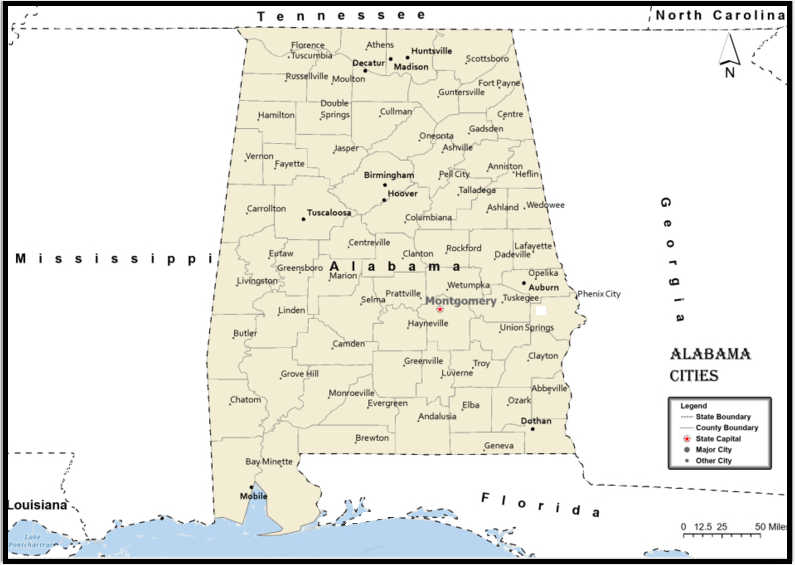
Towns and Cities of Alabama
A
- Abbeville, AL
- Adamsville, AL
- Addison, AL
- Akron, AL
- Alabaster, AL
- Albertville, AL
- Alexander City, AL
- Alexandria, AL
- Aliceville, AL
- Allgood, AL
- Altoona, AL
- Andalusia, AL
- Anderson, AL
- Anniston, AL
- Arab, AL
- Ardmore, AL
- Ariton, AL
- Arley, AL
- Ashford, AL
- Ashland, AL
- Ashville, AL
- Athens, AL
- Atmore, AL
- Attalla, AL
- Auburn, AL
- Autaugaville, AL
B
- Baileyton, AL
- Banks, AL
- Bay Minette, AL
- Bayou La Batre, AL
- Bear Creek, AL
- Beatrice, AL
- Beaverton, AL
- Belk, AL
- Berry, AL
- Bessemer, AL
- Birmingham, AL
- Black, AL
- Blountsville, AL
- Boaz, AL
- Boligee, AL
- Brantley, AL
- Brent, AL
- Brewton, AL
- Bridgeport, AL
- Brilliant, AL
- Brookside, AL
- Brookwood, AL
- Brundidge, AL
- Butler, AL
- Bynum, AL
C
- Calera, AL
- Camden, AL
- Camp Hill, AL
- Carbon Hill, AL
- Carrollton, AL
- Castleberry, AL
- Cedar Bluff, AL
- Centre, AL
- Centreville, AL
- Chatom, AL
- Chelsea, AL
- Cherokee, AL
- Childersburg, AL
- Citronelle, AL
- Clanton, AL
- Clay, AL
- Clayton, AL
- Cleveland, AL
- Clio, AL
- Coaling, AL
- Coffee Springs, AL
- Coffeeville, AL
- Coker, AL
- Collinsville, AL
- Columbia, AL
- Columbiana, AL
- Coosada, AL
- Cordova, AL
- Cottonwood, AL
- Courtland, AL
- Cowarts, AL
- Creola, AL
- Crossville, AL
- Cuba, AL
- Cullman, AL
D
- Dadeville, AL
- Daleville, AL
- Daphne, AL
- Dauphin Island, AL
- Daviston, AL
- Deatsville, AL
- Decatur, AL
- Demopolis, AL
- Detroit, AL
- Dora, AL
- Dothan, AL
- Double Springs, AL
- Douglas, AL
- Dozier, AL
- Dutton, AL
E
- Eclectic, AL
- Elba, AL
- Elberta, AL
- Elkmont, AL
- Enterprise, AL
- Epes, AL
- Eufaula, AL
- Eutaw, AL
- Eva, AL
- Evergreen, AL
- Excel, AL
F
- Fairfield, AL
- Fairhope, AL
- Falkville, AL
- Fayette, AL
- Flomaton, AL
- Florala, AL
- Florence, AL
- Foley, AL
- Forkland, AL
- Fort Deposit, AL
- Fort Payne, AL
- Fort Rucker, AL
- Frisco City, AL
- Fruithurst, AL
- Fulton, AL
- Fultondale, AL
- Fyffe, AL
G
- Gadsden, AL
- Gainesville, AL
- Gantt, AL
- Garden City, AL
- Gardendale, AL
- Geneva, AL
- Georgiana, AL
- Geraldine, AL
- Glen Allen, AL
- Goodwater, AL
- Gordo, AL
- Gordon, AL
- Goshen, AL
- Grand Bay, AL
- Grant, AL
- Graysville, AL
- Greensboro, AL
- Greenville, AL
- Grove Hill, AL
- Guin, AL
- Gulf Shores, AL
- Guntersville, AL
- Gurley, AL
H
- Hackleburg, AL
- Haleyville, AL
- Hamilton, AL
- Hanceville, AL
- Harpersville, AL
- Hartford, AL
- Hartselle, AL
- Harvest, AL
- Hayden, AL
- Hayneville, AL
- Hazel Green, AL
- Headland, AL
- Heflin, AL
- Helena, AL
- Henagar, AL
- Hillsboro, AL
- Hodges, AL
- Holly Pond, AL
- Hollywood, AL
- Huntsville, AL
- Hurtsboro, AL
I
- Ider, AL
J
- Jackson, AL
- Jacksons Gap, AL
- Jacksonville, AL
- Jasper, AL
- Jemison, AL
K
- Kansas, AL
- Kennedy, AL
- Killen, AL
- Kimberly, AL
- Kinston, AL
L
- Lanett, AL
- Langston, AL
- Leeds, AL
- Leesburg, AL
- Leighton, AL
- Lexington, AL
- Lincoln, AL
- Linden, AL
- Lineville, AL
- Lisman, AL
- Livingston, AL
- Lockhart, AL
- Locust Fork, AL
- Louisville, AL
- Loxley, AL
- Luverne, AL
- Lynn, AL
M
- Madison, AL
- Malvern, AL
- Maplesville, AL
- Margaret, AL
- Marion, AL
- Mc Intosh, AL
- Mc Kenzie, AL
- Mentone, AL
- Meridianville, AL
- Midland City, AL
- Midway, AL
- Millbrook, AL
- Millport, AL
- Millry, AL
- Mobile, AL
- Monroeville, AL
- Montevallo, AL
- Montgomery, AL
- Moody, AL
- Morris, AL
- Moulton, AL
- Moundville, AL
- Mount Olive, AL
- Mount Vernon, AL
- Mulga, AL
- Munford, AL
- Muscle Shoals, AL
N
- Nauvoo, AL
- New Brockton, AL
- New Hope, AL
- New Market, AL
- Newbern, AL
- Newton, AL
- Newville, AL
- Northport, AL
- Notasulga, AL
O
- Oakman, AL
- Odenville, AL
- Ohatchee, AL
- Oneonta, AL
- Opelika, AL
- Opp, AL
- Orange Beach, AL
- Orrville, AL
- Owens Cross Roads, AL
- Oxford, AL
- Ozark, AL
P
- Parrish, AL
- Pelham, AL
- Pell City, AL
- Pennington, AL
- Phenix City, AL
- Phil Campbell, AL
- Piedmont, AL
- Pike Road, AL
- Pinckard, AL
- Pine Hill, AL
- Pinson, AL
- Pisgah, AL
- Pleasant Grove, AL
- Point Clear, AL
- Prattville, AL
R
- Ragland, AL
- Rainbow City, AL
- Rainsville, AL
- Ranburne, AL
- Red Bay, AL
- Red Level, AL
- Reform, AL
- Repton, AL
- River Falls, AL
- Riverside, AL
- Roanoke, AL
- Robertsdale, AL
- Rockford, AL
- Rogersville, AL
- Russellville, AL
- Rutledge, AL
S
- Samson, AL
- Saraland, AL
- Satsuma, AL
- Scottsboro, AL
- Section, AL
- Selma, AL
- Sheffield, AL
- Shorter, AL
- Silas, AL
- Silverhill, AL
- Sipsey, AL
- Slocomb, AL
- Somerville, AL
- Spanish Fort, AL
- Springville, AL
- Steele, AL
- Stevenson, AL
- Sulligent, AL
- Sumiton, AL
- Summerdale, AL
- Sweet Water, AL
- Sylacauga, AL
- Sylvania, AL
T
- Talladega, AL
- Tallassee, AL
- Theodore, AL
- Thomaston, AL
- Thomasville, AL
- Thorsby, AL
- Town Creek, AL
- Trafford, AL
- Trinity, AL
- Troy, AL
- Trussville, AL
- Tuscaloosa, AL
- Tuscumbia, AL
- Tuskegee, AL
U
- Union Springs, AL
- Uniontown, AL
V
- Valley Head, AL
- Valley, AL
- Vance, AL
- Vernon, AL
- Vina, AL
- Vincent, AL
- Vredenburgh, AL
W
- Wadley, AL
- Walnut Grove, AL
- Warrior, AL
- Waterloo, AL
- Weaver, AL
- Webb, AL
- Wedowee, AL
- West Blocton, AL
- Wetumpka, AL
- Wilsonville, AL
- Wilton, AL
- Winfield, AL
- Woodville, AL
Y
- York, AL
Counties of Alabama
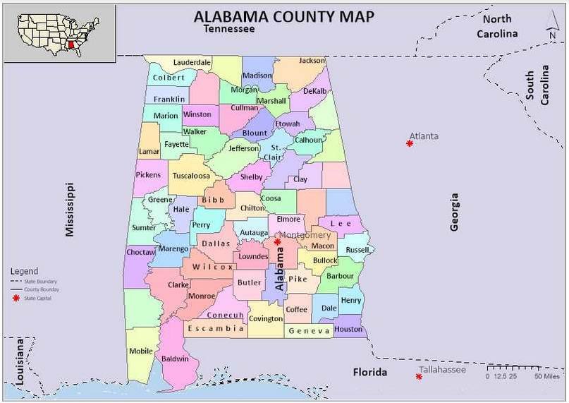
| County | County Seat | Population | Area | Formed |
|---|---|---|---|---|
| Autauga County | Prattville | 55,514 | 594 sq mi | 1818 |
| Baldwin County | Bay Minette | 190,790 | 1,590 sq mi | 1809 |
| Barbour County | Clayton | 27,201 | 885 sq mi | 1832 |
| Bibb County | Centreville | 22,597 | 623 sq mi | 1818 |
| Blount County | Oneonta | 57,826 | 645 sq mi | 1818 |
| Bullock County | Union Springs | 10,474 | 623 sq mi | 1866 |
| Butler County | Greenville | 20,307 | 777 sq mi | 1819 |
| Calhoun County | Anniston | 117,296 | 606 sq mi | 1832 |
| Chambers County | LaFayette | 34,064 | 597 sq mi | 1832 |
| Cherokee County | Centre | 26,021 | 554 sq mi | 1836 |
| Chilton County | Clanton | 43,819 | 693 sq mi | 1868 |
| Choctaw County | Butler | 13,633 | 914 sq mi | 1847 |
| Clarke County | Grove Hill | 25,161 | 1,238 sq mi | 1812 |
| Clay County | Ashland | 13,435 | 604 sq mi | 1866 |
| Cleburne County | Heflin | 14,832 | 560 sq mi | 1866 |
| Coffee County | Elba and Enterprise | 51,252 | 679 sq mi | 1841 |
| Colbert County | Tuscumbia | 54,446 | 593 sq mi | 1867 |
| Conecuh County | Evergreen | 12,981 | 850 sq mi | 1818 |
| Coosa County | Rockford | 10,966 | 651 sq mi | 1832 |
| Covington County | Andalusia | 37,955 | 1,030 sq mi | 1821 |
| Crenshaw County | Luverne | 14,083 | 609 sq mi | 1866 |
| Cullman County | Cullman | 80,440 | 735 sq mi | 1877 |
| Dale County | Ozark | 50,444 | 561 sq mi | 1824 |
| Dallas County | Selma | 43,820 | 979 sq mi | 1818 |
| DeKalb County | Fort Payne | 71,109 | 777 sq mi | 1836 |
| Elmore County | Wetumpka | 79,303 | 618 sq mi | 1866 |
| Escambia County | Brewton | 38,319 | 945 sq mi | 1868 |
| Etowah County | Gadsden | 104,430 | 535 sq mi | 1866 |
| Fayette County | Fayette | 17,241 | 628 sq mi | 1824 |
| Franklin County | Russellville | 31,704 | 634 sq mi | 1818 |
| Geneva County | Geneva | 26,790 | 574 sq mi | 1868 |
| Greene County | Eutaw | 9,045 | 647 sq mi | 1819 |
| Hale County | Greensboro | 15,760 | 644 sq mi | 1867 |
| Henry County | Abbeville | 17,302 | 562 sq mi | 1819 |
| Houston County | Dothan | 101,547 | 580 sq mi | 1903 |
| Jackson County | Scottsboro | 53,227 | 1,078 sq mi | 1819 |
| Jefferson County | Birmingham | 658,466 | 1,111 sq mi | 1819 |
| Lamar County | Vernon | 14,564 | 605 sq mi | 1867 |
| Lauderdale County | Florence | 92,709 | 668 sq mi | 1818 |
| Lawrence County | Moulton | 34,339 | 691 sq mi | 1818 |
| Lee County | Opelika | 140,247 | 608 sq mi | 1866 |
| Limestone County | Athens | 82,782 | 560 sq mi | 1818 |
| Lowndes County | Hayneville | 11,299 | 716 sq mi | 1830 |
| Macon County | Tuskegee | 21,452 | 609 sq mi | 1832 |
| Madison County | Huntsville | 334,811 | 802 sq mi | 1808 |
| Marengo County | Linden | 21,027 | 977 sq mi | 1818 |
| Marion County | Hamilton | 30,776 | 742 sq mi | 1818 |
| Marshall County | Guntersville | 93,019 | 566 sq mi | 1836 |
| Mobile County | Mobile | 412,992 | 1,229 sq mi | 1812 |
| Monroe County | Monroeville | 23,068 | 1,026 sq mi | 1815 |
| Montgomery County | Montgomery | 229,363 | 784 sq mi | 1816 |
| Morgan County | Decatur | 119,490 | 579 sq mi | 1818 |
| Perry County | Marion | 10,591 | 720 sq mi | 1819 |
| Pickens County | Carrollton | 19,746 | 881 sq mi | 1820 |
| Pike County | Troy | 32,899 | 672 sq mi | 1821 |
| Randolph County | Wedowee | 22,913 | 581 sq mi | 1832 |
| Russell County | Phenix City | 52,947 | 641 sq mi | 1832 |
| Shelby County | Columbiana | 195,085 | 785 sq mi | 1818 |
| St Clair County | Ashville and Pell City | 83,593 | 632 sq mi | 1818 |
| Sumter County | Livingston | 13,763 | 904 sq mi | 1832 |
| Talladega County | Talladega | 82,291 | 737 sq mi | 1832 |
| Tallapoosa County | Dadeville | 41,616 | 717 sq mi | 1832 |
| Tuscaloosa County | Tuscaloosa | 194,656 | 1,322 sq mi | 1818 |
| Walker County | Jasper | 67,023 | 791 sq mi | 1823 |
| Washington County | Chatom | 17,581 | 1,080 sq mi | 1800 |
| Wilcox County | Camden | 11,670 | 888 sq mi | 1819 |
| Winston County | Double Springs | 24,484 | 613 sq mi | 1850 |
1. Baldwin County
County Seat: Bay Minette
- Area: 2,027 square miles
- Population: Approximately 239,589 (2020 census)
- Area Codes: 251
- Latitude: 30.6592° N
- Longitude: 87.7460° W
Location and History
Baldwin County is located in the southwestern part of Alabama and is the largest county by area in the state. It was established on December 21, 1809, from parts of Washington County. The county is named after Abraham Baldwin, a U.S. Senator from Georgia. Baldwin County’s early history is marked by its strategic location along the Gulf of Mexico, making it a significant site during the colonial period and the Civil War. The county has evolved from an area dominated by agriculture and fishing to one that includes diverse economic activities, including tourism, due to its beautiful Gulf Coast beaches.
Major Highways and Landmarks
Baldwin County is well-connected by several major highways, including Interstate 10, which runs east-west across the county, and U.S. Highways 31, 90, and 98. The county is home to several notable landmarks, such as Gulf State Park, the USS Alabama Battleship Memorial Park, and historic Fort Morgan. The county also boasts a rich cultural heritage, with landmarks such as the Baldwin County Courthouse in Bay Minette and the Eastern Shore Art Center in Fairhope.
2. Mobile County
County Seat: Mobile
- Area: 1,644 square miles
- Population: Approximately 414,659 (2020 census)
- Area Codes: 251
- Latitude: 30.6954° N
- Longitude: 88.0399° W
Location and History
Mobile County is situated in the southwestern corner of Alabama, bordering the Gulf of Mexico and Mississippi. It was established on December 18, 1812, from parts of Washington County and was named after the indigenous Mobile tribe. Mobile County has a rich history dating back to its founding by the French in 1702. The city of Mobile, one of the oldest in the United States, played a critical role in various historical events, including the Civil War. The county’s strategic location as a port city has shaped its economy, making it a hub for trade, shipbuilding, and manufacturing.
Major Highways and Landmarks
Mobile County is served by Interstate 10 and Interstate 65, which facilitate travel across the region. Major U.S. Highways include 43, 45, 90, and 98. The county is known for landmarks such as the historic Fort Conde, the USS Alabama Battleship, and Bellingrath Gardens and Home. Mobile County also hosts the annual Mardi Gras celebration, one of the oldest in the United States. Additionally, the county is home to the Mobile-Tensaw River Delta, one of the largest river delta systems in the United States.
3. Jefferson County
County Seat: Birmingham
- Area: 1,124 square miles
- Population: Approximately 674,721 (2020 census)
- Area Codes: 205, 659
- Latitude: 33.5186° N
- Longitude: 86.8104° W
Location and History
Jefferson County is located in the central part of Alabama and is the most populous county in the state. It was established on December 13, 1819, and was named after Thomas Jefferson, the third President of the United States. The county’s history is closely tied to the development of the steel industry, particularly in its county seat, Birmingham, which earned the nickname “The Magic City” due to its rapid growth. Jefferson County played a significant role in the civil rights movement during the 1950s and 1960s, with Birmingham being a focal point for protests and demonstrations.
Major Highways and Landmarks
Jefferson County is a major transportation hub with Interstates 20, 22, 59, and 65 passing through it. The county is also served by U.S. Highways 31, 78, 280, and 411. Significant landmarks in Jefferson County include the Birmingham Civil Rights Institute, Vulcan Park and Museum, and the Alabama Theatre. The county is also home to Red Mountain Park, one of the largest urban parks in the United States. Additionally, the University of Alabama at Birmingham (UAB) contributes to the county’s status as a center for education and healthcare.
4. Madison County
County Seat: Huntsville
- Area: 813 square miles
- Population: Approximately 388,153 (2020 census)
- Area Codes: 256, 938
- Latitude: 34.7304° N
- Longitude: 86.5861° W
Location and History
Madison County is located in the northern part of Alabama, bordering Tennessee. It was established on December 13, 1808, and was named after James Madison, the fourth President of the United States. Huntsville, the county seat, is known as “Rocket City” due to its significant contributions to the U.S. space program, particularly through NASA’s Marshall Space Flight Center. The county’s early history was dominated by cotton plantations, but its economy transitioned to technology and aerospace industries during the 20th century.
Major Highways and Landmarks
Madison County is well-served by Interstate 565, which connects the area to other parts of the state, and U.S. Highways 72 and 431. Major landmarks include the U.S. Space & Rocket Center, Monte Sano State Park, and the Huntsville Botanical Garden. The county is also home to Redstone Arsenal, a key military installation that supports the U.S. Army and NASA. Additionally, historic sites such as the Twickenham Historic District and Constitution Hall Park reflect the county’s rich history.
5. Shelby County
County Seat: Columbiana
- Area: 810 square miles
- Population: Approximately 223,024 (2020 census)
- Area Codes: 205, 659
- Latitude: 33.1825° N
- Longitude: 86.6091° W
Location and History
Shelby County is situated in the central part of Alabama, just southeast of Birmingham. It was established on February 7, 1818, and is named after Isaac Shelby, a Revolutionary War hero and the first Governor of Kentucky. The county’s history is rooted in agriculture, but it has grown into one of the most prosperous counties in the state, with a diverse economy that includes manufacturing, services, and retail. The county’s proximity to Birmingham has also spurred suburban development, making it one of the fastest-growing counties in Alabama.
Major Highways and Landmarks
Shelby County is traversed by Interstate 65, which runs north-south, and U.S. Highway 280, a major east-west route. Key landmarks include Oak Mountain State Park, the largest state park in Alabama, and the American Village, a living history museum in Montevallo. The county is also home to the University of Montevallo, Alabama’s only public liberal arts college. Additionally, the county features numerous recreational areas, such as Lay Lake and the Shelby County Museum and Archives in Columbiana, which preserves the county’s history.
6. Tuscaloosa County
County Seat: Tuscaloosa
- Area: 1,351 square miles
- Population: Approximately 227,036 (2020 census)
- Area Codes: 205, 659
- Latitude: 33.2098° N
- Longitude: 87.5692° W
Location and History
Tuscaloosa County is located in the west-central part of Alabama, along the Black Warrior River. It was established on February 6, 1818, and named after the Native American chief Tuskaloosa, who fought against Hernando de Soto in 1540. The county’s history is closely linked to the University of Alabama, which was established in 1831 and became a major center of education and culture in the state. Tuscaloosa, the county seat, served as the state capital from 1826 to 1846 before it was moved to Montgomery.
Major Highways and Landmarks
Tuscaloosa County is served by major highways such as Interstates 20 and 59, which merge as they pass through the county, and U.S. Highways 11, 43, 82, and 69. Major landmarks include the University of Alabama campus, the Bryant-Denny Stadium, and the Paul W. Bryant Museum. The county is also home to Lake Tuscaloosa and Moundville Archaeological Park, one of the most significant prehistoric Native American sites in the United States. Additionally, the Tuscaloosa Amphitheater and the Tuscaloosa Riverwalk are popular destinations for residents and visitors alike.
7. Covington County
County Seat: Andalusia
- Area: 1,044 square miles
- Population: Approximately 37,570 (2020 census)
- Area Codes: 334
- Latitude: 31.3088° N
- Longitude: 86.5023° W
Location and History
Covington County is located in the southern part of Alabama, near the Florida border. It was established on December 17, 1821, and named after Brigadier General Leonard Covington, a hero of the War of 1812. The county’s early history was influenced by its location along the Conecuh River, which facilitated the transport of timber and other goods. Agriculture, particularly cotton, was the dominant industry in the county for many years. The county seat, Andalusia, developed as a center of trade and commerce, especially with the arrival of the railroad in the late 19th century.
Major Highways and Landmarks
Covington County is accessible via major highways, including U.S. Highways 29, 84, and 331, which connect it to other parts of Alabama and Florida. Key landmarks in the county include the Three Notch Museum in Andalusia, which preserves the county’s history, and Frank Jackson State Park, a popular destination for fishing and camping. The Conecuh National Forest, which extends into Covington County, offers additional recreational opportunities. The county is also known for its annual events, such as the World Championship Domino Tournament held in Andalusia.
8. Montgomery County
County Seat: Montgomery
- Area: 800 square miles
- Population: Approximately 226,941 (2020 census)
- Area Codes: 334
- Latitude: 32.3668° N
- Longitude: 86.3000° W
Location and History
Montgomery County is located in the central part of Alabama and is home to the state capital, Montgomery. The county was established on December 6, 1816, and was named after Major Lemuel P. Montgomery, a hero of the Battle of Horseshoe Bend during the War of 1812. Montgomery’s history is deeply intertwined with significant events in American history, including the Civil War and the civil rights movement. The city served as the first capital of the Confederacy and was later the site of the Montgomery Bus Boycott, which marked a pivotal moment in the civil rights movement.
Major Highways and Landmarks
Montgomery County is served by major highways such as Interstates 65 and 85, which intersect in Montgomery, and U.S. Highways 80, 231, and 331. Major landmarks include the Alabama State Capitol, the Dexter Avenue King Memorial Baptist Church, and the Rosa Parks Museum. The county is also home to the Montgomery Museum of Fine Arts, the Alabama Shakespeare Festival, and the Montgomery Zoo. Additionally, historic sites such as Old Alabama Town and the First White House of the Confederacy attract visitors interested in the county’s rich history.
9. Houston County
County Seat: Dothan
- Area: 582 square miles
- Population: Approximately 107,202 (2020 census)
- Area Codes: 334
- Latitude: 31.1566° N
- Longitude: 85.3550° W
Location and History
Houston County is located in the southeastern corner of Alabama, bordering Georgia and Florida. It was established on February 9, 1903, and was named after George S. Houston, a former governor of Alabama. The county seat, Dothan, is known as the “Peanut Capital of the World” due to its significant peanut production. Houston County’s history is relatively recent compared to other Alabama counties, with Dothan developing rapidly in the early 20th century as an agricultural and commercial center. The arrival of the railroad further spurred growth, making Dothan a key trade hub in the region.
Major Highways and Landmarks
Houston County is served by major highways such as U.S. Highways 84, 231, and 431, which connect it to nearby states and major cities. Notable landmarks include the Dothan Area Botanical Gardens, Landmark Park, and the Wiregrass Museum of Art. The county also hosts the annual National Peanut Festival, celebrating the region’s agricultural heritage. The Dothan Opera House and the George Washington Carver Interpretive Museum are important cultural sites, reflecting the county’s rich history and diverse community.
10. Lee County
County Seat: Opelika
- Area: 616 square miles
- Population: Approximately 174,241 (2020 census)
- Area Codes: 334
- Latitude: 32.6010° N
- Longitude: 85.3535° W
Location and History
Lee County is located in the eastern part of Alabama, bordering Georgia. It was established on December 5, 1866, and was named after Confederate General Robert E. Lee. The county seat, Opelika, developed as a key railroad hub in the late 19th century, while the nearby city of Auburn became known for its university, Auburn University, which was established in 1856. The county’s history is closely tied to agriculture, particularly cotton, but it has diversified over the years, with education, manufacturing, and services becoming dominant sectors.
Major Highways and Landmarks
Lee County is well-connected by major highways, including Interstate 85, which runs through the county, and U.S. Highways 29 and 280. Key landmarks include Auburn University, which is the heart of the county’s educational and cultural life, and Chewacla State Park, offering outdoor recreation. The Jule Collins Smith Museum of Fine Art in Auburn and the Opelika Historic District are also significant cultural sites. Additionally, the county hosts various annual events, such as Auburn’s A-Day football game and the Opelika Christmas Parade, reflecting the county’s vibrant community life.
- Autauga County, AL
- Baldwin County, AL
- Barbour County, AL
- Bibb County, AL
- Blount County, AL
- Bullock County, AL
- Butler County, AL
- Calhoun County, AL
- Chambers County, AL
- Cherokee County, AL
- Chilton County, AL
- Choctaw County, AL
- Clarke County, AL
- Clay County, AL
- Cleburne County, AL
- Coffee County, AL
- Colbert County, AL
- Conecuh County, AL
- Coosa County, AL
- Covington County, AL
- Crenshaw County, AL
- Cullman County, AL
- Dale County, AL
- Dallas County, AL
- DeKalb County, AL
- Elmore County, AL
- Escambia County, AL
- Etowah County, AL
- Fayette County, AL
- Franklin County, AL
- Geneva County, AL
- Greene County, AL
- Hale County, AL
- Henry County, AL
- Houston County, AL
- Jackson County, AL
- Jefferson County, AL
- Lamar County, AL
- Lauderdale County, AL
- Lawrence County, AL
- Lee County, AL
- Limestone County, AL
- Lowndes County, AL
- Macon County, AL
- Madison County, AL
- Marengo County, AL
- Marion County, AL
- Marshall County, AL
- Mobile County, AL
- Monroe County, AL
- Montgomery County, AL
- Morgan County, AL
- Perry County, AL
- Pickens County, AL
- Pike County, AL
- Randolph County, AL
- Russell County, AL
- Saint Clair County, AL
- Shelby County, AL
- Sumter County, AL
- Talladega County, AL
- Tallapoosa County, AL
- Tuscaloosa County, AL
- Walker County, AL
- Washington County, AL
- Wilcox County, AL
- Winston County, AL
—————————————————————————————————————————————–