![SolutionCenters (Americas) [Beta]](https://solutioncenters.org/wp-content/uploads/2026/02/SCUS-Lg-Copy-2.png)
New Mexico
| Rank | Name | Population | Density (mi²) | Area (mi²) |
|---|---|---|---|---|
| 1 | Albuquerque | 562,281 | 3,003 | 187.22 |
| 2 | Las Cruces | 104,672 | 1,361 | 76.93 |
| 3 | Rio Rancho | 101,570 | 982 | 103.42 |
| 4 | Santa Fe | 85,627 | 1,639 | 52.23 |
| 5 | Roswell | 47,589 | 1,601 | 29.72 |
| 6 | Farmington | 43,278 | 1,256 | 34.46 |
| 7 | Hobbs | 41,085 | 1,556 | 26.4 |
| 8 | South Valley | 40,080 | 1,381 | 29.02 |
| 9 | Clovis | 37,765 | 1,599 | 23.61 |
| 10 | Alamogordo | 32,734 | 1,530 | 21.39 |
| 11 | Carlsbad | 30,922 | 991 | 31.21 |
| 12 | Gallup | 21,115 | 1,056 | 19.99 |
| 13 | Sunland Park | 18,682 | 1,435 | 13.02 |
| 14 | Los Lunas | 16,583 | 885 | 18.73 |
| 15 | Chaparral | 14,437 | 244 | 59.06 |
| 16 | Deming | 13,644 | 817 | 16.7 |
| 17 | North Valley | 13,449 | 1,935 | 6.95 |
| 18 | Las Vegas | 12,687 | 1,622 | 7.82 |
| 19 | Los Alamos | 12,666 | 1,139 | 11.13 |
| 20 | Artesia | 12,558 | 1,143 | 10.98 |
| 21 | Lovington | 11,863 | 1,044 | 11.36 |
| 22 | Portales | 11,300 | 1,423 | 7.94 |
| 23 | Bernalillo | 11,289 | 2,310 | 4.89 |
| 24 | Espanola | 10,022 | 1,286 | 7.79 |
| 25 | Anthony | 9,163 | 3,394 | 2.7 |
| 26 | Silver City | 9,162 | 905 | 10.12 |
| 27 | Shiprock | 9,020 | 668 | 13.51 |
| 28 | Grants | 8,866 | 595 | 14.91 |
| 29 | Corrales | 8,778 | 814 | 10.78 |
| 30 | Socorro | 8,274 | 572 | 14.45 |
| 31 | Ruidoso | 8,013 | 498 | 16.08 |
| 32 | Bloomfield | 7,485 | 404 | 18.55 |
| 33 | Belen | 7,430 | 392 | 18.95 |
| 34 | Zuni Pueblo | 7,001 | 791 | 8.85 |
| 35 | North Hobbs | 6,301 | 242 | 26.04 |
| 36 | Aztec | 6,197 | 492 | 12.61 |
| 37 | Edgewood | 6,131 | 108 | 56.8 |
| 38 | Los Ranchos de Albuquerque | 6,120 | 1,375 | 4.45 |
| 39 | Los Chaves | 6,109 | 595 | 10.28 |
| 40 | Taos | 5,887 | 980 | 6.01 |
| 41 | Eldorado at Santa Fe | 5,823 | 280 | 20.77 |
| 42 | Raton | 5,802 | 729 | 7.96 |
| 43 | White Rock | 5,751 | 814 | 7.07 |
| 44 | Lee Acres | 5,735 | 442 | 12.99 |
| 45 | Truth or Consequences | 5,567 | 199 | 28 |
| 46 | Santa Teresa | 5,515 | 551 | 10 |
| 47 | Tucumcari | 4,871 | 512 | 9.51 |
| 48 | Placitas | 4,686 | 158 | 29.71 |
| 49 | Paradise Hills | 4,656 | 4,551 | 1.02 |
| 50 | Rio Communities | 4,538 | 590 | 7.69 |
| 51 | El Cerro Mission | 4,170 | 709 | 5.88 |
| 52 | Holloman AFB | 4,096 | 326 | 12.55 |
| 53 | Bosque Farms | 3,900 | 991 | 3.94 |
| 54 | Meadow Lake | 3,832 | 332 | 11.54 |
| 55 | La Cienega | 3,732 | 327 | 11.41 |
| 56 | Milan | 3,671 | 846 | 4.34 |
| 57 | Peralta | 3,600 | 810 | 4.44 |
| 58 | Sandia Heights | 3,571 | 1,893 | 1.89 |
| 59 | El Cerro | 3,202 | 759 | 4.22 |
| 60 | Eunice | 3,144 | 797 | 3.94 |
| 61 | Vado | 3,099 | 1,041 | 2.98 |
| 62 | Tularosa | 3,078 | 1,092 | 2.82 |
| 63 | University Park | 2,945 | 1,919 | 1.53 |
| 64 | West Hammond | 2,777 | 357 | 7.78 |
| 65 | Dulce | 2,750 | 215 | 12.81 |
| 66 | Agua Fria | 2,734 | 1,128 | 2.42 |
| 67 | Chimayo | 2,641 | 307 | 8.59 |
| 68 | Clayton | 2,621 | 337 | 7.78 |
| 69 | Santa Rosa | 2,600 | 520 | 5 |
| 70 | Ruidoso Downs | 2,568 | 678 | 3.79 |
| 71 | Cannon AFB | 2,475 | 422 | 5.87 |
| 72 | Crownpoint | 2,419 | 343 | 7.05 |
| 73 | Lordsburg | 2,354 | 279 | 8.43 |
| 74 | La Mesilla | 2,314 | 520 | 4.45 |
| 75 | Santo Domingo Pueblo | 2,292 | 1,125 | 2.04 |
| 76 | San Felipe Pueblo | 2,217 | 185 | 11.98 |
| 77 | Jal | 2,185 | 453 | 4.82 |
| 78 | Ranchos de Taos | 2,178 | 618 | 3.53 |
| 79 | Boles Acres | 2,173 | 179 | 12.17 |
| 80 | Bayard | 2,071 | 2,178 | 0.95 |
| 81 | San Ysidro | 2,060 | 779 | 2.65 |
| 82 | Pojoaque | 2,027 | 464 | 4.37 |
| 83 | Jarales | 2,026 | 232 | 8.72 |
| 84 | Jemez Pueblo | 2,018 | 1,017 | 1.98 |
| 85 | Valencia | 2,018 | 988 | 2.04 |
| 86 | El Valle de Arroyo Seco | 2,009 | 387 | 5.19 |
| 87 | Tome | 1,988 | 402 | 4.95 |
| 88 | Berino | 1,877 | 2,020 | 0.93 |
| 89 | Moriarty | 1,846 | 266 | 6.93 |
| 90 | Nambe | 1,820 | 209 | 8.69 |
| 91 | Arenas Valley | 1,813 | 446 | 4.07 |
| 92 | Mesilla | 1,804 | 326 | 5.53 |
| 93 | Arroyo Seco | 1,794 | 263 | 6.83 |
| 94 | Questa | 1,753 | 343 | 5.11 |
| 95 | Santa Clara | 1,727 | 1,264 | 1.37 |
| 96 | Las Maravillas | 1,723 | 1,706 | 1.01 |
| 97 | Keeler Farm | 1,706 | 150 | 11.39 |
| 98 | Flora Vista | 1,688 | 366 | 4.61 |
| 99 | Upper Fruitland | 1,686 | 224 | 7.52 |
| 100 | Black Rock | 1,656 | 980 | 1.69 |
| 101 | Hatch | 1,648 | 521 | 3.16 |
| 102 | Thoreau | 1,641 | 103 | 15.91 |
| 103 | Waterflow | 1,623 | 189 | 8.6 |
| 104 | Spencerville | 1,609 | 481 | 3.35 |
| 105 | La Huerta | 1,608 | 1,032 | 1.56 |
| 106 | Monterey Park | 1,600 | 605 | 2.65 |
| 107 | Columbus | 1,599 | 343 | 4.67 |
| 108 | Estancia | 1,567 | 254 | 6.17 |
| 109 | Sausal | 1,566 | 693 | 2.26 |
| 110 | Sandia Knolls | 1,475 | 526 | 2.8 |
| 111 | Radium Springs | 1,467 | 246 | 5.97 |
| 112 | Navajo | 1,450 | 644 | 2.25 |
| 113 | Capitan | 1,439 | 442 | 3.26 |
| 114 | Taos Pueblo | 1,425 | 91 | 15.6 |
| 115 | San Rafael | 1,413 | 137 | 10.32 |
| 116 | Loving | 1,405 | 1,200 | 1.17 |
| 117 | Pecos | 1,308 | 750 | 1.75 |
| 118 | Carnuel | 1,305 | 245 | 5.32 |
| 119 | Fairacres | 1,294 | 614 | 2.11 |
| 120 | Elephant Butte | 1,278 | 306 | 4.18 |
| 121 | Ohkay Owingeh | 1,256 | 327 | 3.84 |
| 122 | Dexter | 1,251 | 1,716 | 0.73 |
| 123 | White Sands | 1,246 | 363 | 3.43 |
| 124 | Mescalero | 1,244 | 70 | 17.89 |
| 125 | La Luz | 1,222 | 114 | 10.68 |
| 126 | Hagerman | 1,220 | 900 | 1.36 |
| 127 | Atoka | 1,193 | 176 | 6.76 |
| 128 | El Rancho | 1,183 | 564 | 2.1 |
| 129 | Ponderosa Pine | 1,159 | 144 | 8.07 |
| 130 | Dona Ana | 1,158 | 1,812 | 0.64 |
| 131 | San Antonito | 1,150 | 471 | 2.44 |
| 132 | Hurley | 1,146 | 1,124 | 1.02 |
| 133 | Twin Lakes | 1,117 | 124 | 9.02 |
| 134 | Indian Hills | 1,075 | 98 | 10.93 |
| 135 | Laguna | 1,075 | 188 | 5.71 |
| 136 | Skyline-Ganipa | 1,055 | 171 | 6.16 |
| 137 | Angel Fire | 1,052 | 37 | 28.8 |
| 138 | Texico | 1,043 | 1,258 | 0.83 |
| 139 | San Pablo | 1,019 | 837 | 1.22 |
| 140 | Tesuque | 1,008 | 177 | 5.68 |
| 141 | La Union | 994 | 240 | 4.14 |
| 142 | Logan | 991 | 94 | 10.6 |
| 143 | Chama | 986 | 359 | 2.75 |
| 144 | Sedillo | 986 | 369 | 2.67 |
| 145 | San Miguel | 978 | 427 | 2.29 |
| 146 | La Puebla | 952 | 313 | 3.04 |
| 147 | McIntosh | 939 | 35 | 27.03 |
| 148 | Zia Pueblo | 939 | 42 | 22.27 |
| 149 | Talpa | 934 | 712 | 1.31 |
| 150 | Carrizozo | 933 | 112 | 8.36 |
| 151 | Adelino | 919 | 339 | 2.71 |
| 152 | High Rolls | 910 | 59 | 15.41 |
| 153 | Paraje | 903 | 162 | 5.58 |
| 154 | Chamita | 899 | 233 | 3.85 |
| 155 | Church Rock | 887 | 385 | 2.3 |
| 156 | Springer | 886 | 402 | 2.2 |
| 157 | Magdalena | 870 | 140 | 6.22 |
| 158 | Fort Sumner | 867 | 262 | 3.31 |
| 159 | Mountainair | 865 | 547 | 1.58 |
| 160 | Cimarron | 861 | 346 | 2.48 |
| 161 | Midway | 861 | 428 | 2.01 |
| 162 | Tatum | 857 | 541 | 1.58 |
| 163 | Alamo | 851 | 22 | 39.17 |
| 164 | Mesita | 825 | 77 | 10.7 |
| 165 | Santa Clara Pueblo | 820 | 406 | 2.02 |
| 166 | El Rito | 808 | 197 | 4.11 |
| 167 | Mora | 807 | 100 | 8.04 |
| 168 | San Ildefonso Pueblo | 803 | 182 | 4.42 |
| 169 | Morningside | 787 | 8,372 | 0.09 |
| 170 | Tierra Amarilla | 784 | 292 | 2.69 |
| 171 | Happy Valley | 774 | 361 | 2.15 |
| 172 | Cedar Hill | 773 | 144 | 5.36 |
| 173 | Cuba | 761 | 233 | 3.26 |
| 174 | Hernandez | 751 | 443 | 1.7 |
| 175 | El Duende | 743 | 506 | 1.47 |
| 176 | Tohatchi | 741 | 120 | 6.16 |
| 177 | Pena Blanca | 731 | 106 | 6.89 |
| 178 | Napi Headquarters | 728 | 201 | 3.62 |
| 179 | Ventura | 714 | 131 | 5.46 |
| 180 | Cloudcroft | 713 | 437 | 1.63 |
| 181 | Livingston Wheeler | 706 | 430 | 1.64 |
| 182 | Algodones | 704 | 423 | 1.66 |
| 183 | Cordova | 704 | 96 | 7.3 |
| 184 | Cedar Crest | 691 | 222 | 3.11 |
| 185 | Santa Ana Pueblo | 682 | 92 | 7.38 |
| 186 | San Jose | 680 | 2,030 | 0.34 |
| 187 | Tyrone | 680 | 376 | 1.81 |
| 188 | Penasco | 667 | 549 | 1.22 |
| 189 | Lemitar | 653 | 476 | 1.37 |
| 190 | East Pecos | 646 | 180 | 3.6 |
| 191 | Nenahnezad | 644 | 185 | 3.48 |
| 192 | La Mesa | 638 | 269 | 2.37 |
| 193 | Ojo Amarillo | 637 | 324 | 1.97 |
| 194 | Chamberino | 625 | 204 | 3.06 |
| 195 | Glorieta | 618 | 81 | 7.65 |
| 196 | Melrose | 615 | 364 | 1.69 |
| 197 | Los Luceros | 604 | 369 | 1.64 |
| 198 | Rodey | 594 | 1,053 | 0.56 |
| 199 | Madrone | 590 | 192 | 3.08 |
| 200 | La Hacienda | 587 | 434 | 1.35 |
| 201 | Kirtland | 581 | 337 | 1.72 |
| 202 | Acomita Lake | 574 | 166 | 3.45 |
| 203 | La Villita | 573 | 421 | 1.36 |
| 204 | Mimbres | 572 | 129 | 4.44 |
| 205 | Ribera | 552 | 219 | 2.52 |
| 206 | Chili | 549 | 167 | 3.28 |
| 207 | Yah-ta-hey | 548 | 138 | 3.98 |
| 208 | Tijeras | 537 | 474 | 1.13 |
| 209 | Cedar Grove | 535 | 30 | 17.99 |
| 210 | Canada de los Alamos | 511 | 139 | 3.68 |
| 211 | Rock Springs | 506 | 87 | 5.81 |
| 212 | La Plata | 503 | 50 | 10.15 |
| 213 | Sanostee | 500 | 110 | 4.54 |
| 214 | Cochiti Lake | 487 | 392 | 1.24 |
| 215 | San Fidel | 473 | 112 | 4.21 |
| 216 | Red River | 459 | 452 | 1.01 |
| 217 | Highland Meadows | 451 | 65 | 6.92 |
| 218 | Pleasanton | 450 | 295 | 1.52 |
| 219 | Cochiti | 445 | 571 | 0.78 |
| 220 | Cuyamungue | 431 | 369 | 1.17 |
| 221 | Ramah | 427 | 112 | 3.81 |
| 222 | Rio Lucio | 424 | 403 | 1.05 |
| 223 | Pueblo of Sandia Village | 422 | 372 | 1.13 |
| 224 | Lake Arthur | 418 | 786 | 0.53 |
| 225 | Peak Place | 409 | 313 | 1.31 |
| 226 | Mesquite | 408 | 499 | 0.82 |
| 227 | Cedro | 402 | 1,500 | 0.27 |
| 228 | Isleta Village Proper | 402 | 75 | 5.39 |
| 229 | Williamsburg | 396 | 815 | 0.49 |
| 230 | Pueblo Pintado | 388 | 37 | 10.56 |
| 231 | Jacona | 387 | 457 | 0.85 |
| 232 | Dixon | 386 | 33 | 11.53 |
| 233 | Vaughn | 385 | 69 | 5.6 |
| 234 | Naschitti | 383 | 153 | 2.51 |
| 235 | Paguate | 379 | 51 | 7.41 |
| 236 | Pinos Altos | 372 | 492 | 0.76 |
| 237 | Seama | 368 | 59 | 6.25 |
| 238 | Rincon | 365 | 370 | 0.99 |
| 239 | Placitas | 364 | 2,582 | 0.14 |
| 240 | Newcomb | 359 | 60 | 6.02 |
| 241 | Chamisal | 348 | 212 | 1.64 |
| 242 | San Mateo | 346 | 72 | 4.83 |
| 243 | Brimhall Nizhoni | 345 | 79 | 4.38 |
| 244 | Crystal | 345 | 21 | 16.31 |
| 245 | Canjilon | 337 | 105 | 3.21 |
| 246 | Edith Endave | 336 | 222 | 1.51 |
| 247 | Cotton City | 333 | 13 | 25.53 |
| 248 | Cubero | 331 | 35 | 9.37 |
| 249 | Sunshine | 328 | 19 | 17.64 |
| 250 | La Jara | 325 | 23 | 14.25 |
| 251 | Jaconita | 323 | 479 | 0.67 |
| 252 | Pulpotio Bareas | 320 | 620 | 0.52 |
| 253 | Las Palomas | 319 | 52 | 6.11 |
| 254 | Rowe | 319 | 199 | 1.6 |
| 255 | Tesuque Pueblo | 318 | 145 | 2.2 |
| 256 | Vadito | 315 | 365 | 0.86 |
| 257 | Pueblitos | 314 | 147 | 2.14 |
| 258 | Manzano Springs | 311 | 259 | 1.2 |
| 259 | Salem | 311 | 136 | 2.28 |
| 260 | Villanueva | 309 | 43 | 7.26 |
| 261 | Velarde | 302 | 118 | 2.55 |
| 262 | Nakaibito | 297 | 42 | 7 |
| 263 | North Light Plant | 296 | 420 | 0.7 |
| 264 | Beclabito | 295 | 39 | 7.53 |
| 265 | Nadine | 294 | 26 | 11.36 |
| 266 | Abeytas | 293 | 238 | 1.23 |
| 267 | Wagon Mound | 291 | 288 | 1.01 |
| 268 | Encinal | 284 | 21 | 13.47 |
| 269 | Timberon | 275 | 14 | 20.29 |
| 270 | North Acomita Village | 273 | 490 | 0.56 |
| 271 | Reserve | 273 | 95 | 2.86 |
| 272 | Jemez Springs | 267 | 56 | 4.8 |
| 273 | Navajo Dam | 266 | 98 | 2.7 |
| 274 | Pajarito Mesa | 266 | 21 | 12.49 |
| 275 | Tajique | 266 | 148 | 1.8 |
| 276 | Ponderosa | 255 | 28 | 9.13 |
| 277 | Tecolotito | 254 | 353 | 0.72 |
| 278 | Sheep Springs | 250 | 42 | 5.96 |
| 279 | Cruzville | 249 | 393 | 0.63 |
| 280 | Santa Cruz | 249 | 98 | 2.55 |
| 281 | Eagle Nest | 245 | 56 | 4.37 |
| 282 | White Signal | 244 | 38 | 6.43 |
| 283 | Torreon | 243 | 18 | 13.88 |
| 284 | Willard | 242 | 262 | 0.92 |
| 285 | Young Place | 240 | 140 | 1.71 |
| 286 | Sandia Park | 236 | 326 | 0.72 |
| 287 | Galisteo | 234 | 92 | 2.55 |
| 288 | Gila | 226 | 24 | 9.36 |
| 289 | Madrid | 218 | 157 | 1.39 |
| 290 | Cuyamungue Grant | 217 | 86 | 2.54 |
| 291 | San Luis | 212 | 26 | 8.28 |
| 292 | Organ | 210 | 243 | 0.86 |
| 293 | Maxwell | 206 | 435 | 0.47 |
| 294 | Hanover | 205 | 60 | 3.4 |
| 295 | Ute Park | 205 | 147 | 1.4 |
| 296 | Chupadero | 204 | 113 | 1.81 |
| 297 | Bluewater Acres | 202 | 69 | 2.93 |
| 298 | San Jon | 202 | 64 | 3.13 |
| 299 | Torreon | 200 | 24 | 8.25 |
| 300 | Lyden | 199 | 85 | 2.34 |
| 301 | San Ysidro | 199 | 89 | 2.24 |
| 302 | Canon | 198 | 12 | 16.11 |
| 303 | Roy | 195 | 95 | 2.04 |
| 304 | Tse Bonito | 186 | 132 | 1.41 |
| 305 | Twin Forks | 185 | 45 | 4.13 |
| 306 | San Cristobal | 184 | 27 | 6.89 |
| 307 | Nageezi | 183 | 13 | 14.1 |
| 308 | Los Cerrillos | 182 | 54 | 3.37 |
| 309 | Quemado | 177 | 99 | 1.79 |
| 310 | Arroyo Hondo | 176 | 25 | 6.93 |
| 311 | Truchas | 176 | 107 | 1.65 |
| 312 | San Jose | 172 | 649 | 0.27 |
| 313 | Glen Acres | 171 | 181 | 0.94 |
| 314 | Elida | 170 | 166 | 1.02 |
| 315 | Seboyeta | 169 | 15 | 11.51 |
| 316 | Soham | 167 | 108 | 1.55 |
| 317 | San Lorenzo | 166 | 95 | 1.75 |
| 318 | Corona | 165 | 161 | 1.03 |
| 319 | Alcalde | 159 | 61 | 2.59 |
| 320 | Blanco | 159 | 45 | 3.54 |
| 321 | Lamy | 159 | 308 | 0.52 |
| 322 | Hillsboro | 154 | 72 | 2.13 |
| 323 | Abiquiu | 151 | 158 | 0.95 |
| 324 | Buckhorn | 150 | 32 | 4.64 |
| 325 | Tecolote | 149 | 26 | 5.63 |
| 326 | Alamillo | 143 | 119 | 1.2 |
| 327 | Lake Sumner | 142 | 2 | 62.27 |
| 328 | Nogal | 140 | 18 | 7.61 |
| 329 | La Cueva | 137 | 14 | 9.76 |
| 330 | San Pedro | 137 | 83 | 1.65 |
| 331 | Cliff | 135 | 13 | 10.25 |
| 332 | Llano del Medio | 134 | 25 | 5.28 |
| 333 | Monument | 134 | 70 | 1.91 |
| 334 | Virden | 131 | 621 | 0.21 |
| 335 | Polvadera | 126 | 130 | 0.97 |
| 336 | Casa Colorada | 125 | 421 | 0.3 |
| 337 | Mountain View | 125 | 23 | 5.52 |
| 338 | Anton Chico | 124 | 128 | 0.97 |
| 339 | Las Nutrias | 124 | 69 | 1.79 |
| 340 | Watrous | 123 | 216 | 0.57 |
| 341 | Rosedale | 122 | 69 | 1.77 |
| 342 | Gallina | 120 | 27 | 4.5 |
| 343 | Des Moines | 118 | 136 | 0.87 |
| 344 | Lumberton | 116 | 243 | 0.48 |
| 345 | Dora | 115 | 41 | 2.77 |
| 346 | Animas | 114 | 38 | 2.97 |
| 347 | Malaga | 114 | 7 | 15.66 |
| 348 | Fence Lake | 113 | 247 | 0.46 |
| 349 | Picuris Pueblo | 113 | 7 | 16.91 |
| 350 | Pie Town | 111 | 2 | 57.27 |
| 351 | Chical | 108 | 35 | 3.09 |
| 352 | Floyd | 108 | 133 | 0.81 |
| 353 | Hope | 106 | 174 | 0.61 |
| 354 | Pueblito | 106 | 87 | 1.22 |
| 355 | McCartys Village | 103 | 518 | 0.2 |
| 356 | Canova | 102 | 121 | 0.84 |
| 357 | Grady | 99 | 372 | 0.27 |
| 358 | North Hurley | 98 | 64 | 1.53 |
| 359 | Lake Valley | 96 | 12 | 8.35 |
| 360 | Causey | 94 | 25 | 3.75 |
| 361 | Apache Creek | 93 | 64 | 1.45 |
| 362 | Aragon | 93 | 11 | 8.45 |
| 363 | Windmill | 93 | 11 | 8.2 |
| 364 | Canones | 92 | 30 | 3.03 |
| 365 | Costilla | 92 | 22 | 4.14 |
| 366 | Rio en Medio | 89 | 134 | 0.66 |
| 367 | Brazos | 88 | 406 | 0.22 |
| 368 | Sacramento | 86 | 13 | 6.55 |
| 369 | Whites City | 85 | 192 | 0.44 |
| 370 | Luis Lopez | 83 | 88 | 0.95 |
| 371 | Sombrillo | 83 | 154 | 0.54 |
| 372 | Bluewater Village | 82 | 8 | 10.06 |
| 373 | Mosquero | 81 | 81 | 1 |
| 374 | Chamizal | 76 | 38 | 1.99 |
| 375 | Encino | 76 | 172 | 0.44 |
| 376 | Taos Ski Valley | 75 | 26 | 2.85 |
| 377 | Veguita | 73 | 87 | 0.84 |
| 378 | Coyote | 72 | 172 | 0.42 |
| 379 | Escudilla Bonita | 72 | 103 | 0.7 |
| 380 | San Acacia | 72 | 6 | 12.16 |
| 381 | Winston | 72 | 17 | 4.15 |
| 382 | Rodeo | 71 | 9 | 8.19 |
| 383 | Pinehill | 69 | 9 | 7.27 |
| 384 | Regina | 69 | 20 | 3.38 |
| 385 | Oasis | 67 | 32 | 2.09 |
| 386 | Bent | 62 | 4 | 14.18 |
| 387 | House | 62 | 68 | 0.91 |
| 388 | Puerto de Luna | 62 | 10 | 6.14 |
| 389 | Moquino | 58 | 25 | 2.32 |
| 390 | Mayhill | 56 | 6 | 9.5 |
| 391 | Bibo | 55 | 84 | 0.65 |
| 392 | Folsom | 55 | 6 | 8.94 |
| 393 | Chilili | 54 | 29 | 1.86 |
| 394 | Playas | 54 | 54 | 0.99 |
| 395 | Los Ojos | 52 | 37 | 1.39 |
| 396 | North San Ysidro | 51 | 22 | 2.3 |
| 397 | Lake Roberts Heights | 50 | 66 | 0.76 |
| 398 | City of the Sun | 46 | 87 | 0.53 |
| 399 | Faywood | 46 | 182 | 0.25 |
| 400 | Caballo | 45 | 46 | 0.98 |
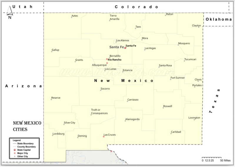
Albuquerque
Population: Albuquerque, the largest city in New Mexico, boasts over 560,000 residents.
Area: Albuquerque spans approximately 189.5 square miles.
Zip Codes: Albuquerque encompasses various zip codes, including 87102, 87109, 87121.
Area Codes: 505, 575
County Affiliated: Bernalillo County
Latitude: 35.0844° N
Longitude: 106.6504° W
Albuquerque, nestled along the Rio Grande, is known for its vibrant culture, scenic landscapes, and historic landmarks. Old Town Albuquerque is a historic district dating back to the city’s founding in 1706, featuring adobe buildings, art galleries, museums, and shops selling Native American crafts and souvenirs, providing visitors with a glimpse into the city’s Spanish colonial past and vibrant present. Sandia Peak Tramway is the longest aerial tramway in the world, ascending over 10,000 feet to the summit of the Sandia Mountains, offering panoramic views of the city, desert, and surrounding mountains, as well as opportunities for hiking, skiing, and mountain biking, providing outdoor enthusiasts with access to alpine adventures just minutes from downtown. Albuquerque International Balloon Fiesta is the largest hot air balloon festival in the world, attracting thousands of visitors each October to watch hundreds of colorful balloons take flight over the city at dawn, as well as enjoy live music, food vendors, and special events, providing a unique and unforgettable experience for spectators and participants alike.
Las Cruces
Population: Las Cruces, the second-largest city in New Mexico, has over 100,000 residents.
Area: Las Cruces covers approximately 76.6 square miles.
Zip Codes: Las Cruces encompasses various zip codes, including 88001, 88011, 88012.
Area Codes: 575
County Affiliated: Doña Ana County
Latitude: 32.3197° N
Longitude: 106.7653° W
Las Cruces, located in the Mesilla Valley, is known for its rich history, cultural diversity, and natural beauty. Organ Mountains-Desert Peaks National Monument is a protected area encompassing over 500,000 acres of rugged mountains, desert landscapes, and archaeological sites, offering opportunities for hiking, camping, birdwatching, and rock climbing, as well as exploring historic trails and learning about the region’s Native American, Hispanic, and pioneer heritage, providing outdoor enthusiasts and history buffs with a scenic and educational destination. Old Mesilla is a historic district dating back to the 1840s, featuring adobe buildings, galleries, boutiques, and restaurants, as well as landmarks such as the San Albino Church and the Fountain Theatre, providing visitors with a taste of the Southwest’s Spanish, Mexican, and American influences, as well as opportunities for shopping, dining, and cultural experiences. New Mexico Farm and Ranch Heritage Museum is a living history museum showcasing the state’s agricultural heritage, featuring exhibits, artifacts, and demonstrations that explore farming, ranching, and rural life in New Mexico, as well as offering educational programs, special events, and hands-on activities for visitors of all ages, providing insights into the region’s agricultural traditions and innovations.
Santa Fe
Population: Santa Fe, the capital city of New Mexico, boasts over 80,000 residents.
Area: Santa Fe spans approximately 37.4 square miles.
Zip Codes: Santa Fe encompasses various zip codes, including 87501, 87505, 87507.
Area Codes: 505
County Affiliated: Santa Fe County
Latitude: 35.6870° N
Longitude: 105.9378° W
Santa Fe, nestled in the Sangre de Cristo Mountains, is known for its adobe architecture, vibrant arts scene, and rich cultural heritage. Santa Fe Plaza is the historic heart of the city, dating back to the early 17th century, featuring adobe buildings, art galleries, shops, and restaurants, as well as landmarks such as the Palace of the Governors and the Cathedral Basilica of St. Francis of Assisi, providing visitors with a glimpse into Santa Fe’s Spanish colonial past and Native American traditions, as well as opportunities for shopping, dining, and people-watching. Canyon Road is an iconic art district lined with galleries, studios, and sculpture gardens showcasing a wide variety of artwork, including paintings, ceramics, jewelry, and textiles, as well as hosting art walks, festivals, and cultural events throughout the year, providing art enthusiasts and collectors with opportunities to explore and purchase works by local and international artists in a scenic and historic setting. Georgia O’Keeffe Museum is a cultural institution dedicated to the life and work of American artist Georgia O’Keeffe, featuring a collection of her paintings, drawings, and sculptures, as well as rotating exhibits, educational programs, and special events that celebrate her contributions to modern art and her connection to the landscapes and cultures of New Mexico, providing visitors with insights into O’Keeffe’s artistic vision and legacy.
Rio Rancho
Population: Rio Rancho, situated in the Albuquerque metropolitan area, has over 100,000 residents.
Area: Rio Rancho covers approximately 103.7 square miles.
Zip Codes: Rio Rancho encompasses various zip codes, including 87124, 87144, 87174.
Area Codes: 505
County Affiliated: Sandoval County
Latitude: 35.2327° N
Longitude: 106.6630° W
Rio Rancho is a growing city known for its suburban neighborhoods, recreational amenities, and scenic vistas. Petroglyph National Monument is a protected area featuring over 20,000 ancient petroglyphs carved into volcanic rocks by Native American tribes and Spanish settlers over 400 years ago, offering hiking trails, interpretive exhibits, and ranger-led programs that explore the cultural and natural history of the region, as well as opportunities for birdwatching, photography, and picnicking, providing visitors with a unique and enriching experience in a desert landscape. Santa Ana Star Center is a multi-purpose arena hosting concerts, sporting events, and community gatherings, as well as offering amenities such as a fitness center, meeting rooms, and a children’s play area, providing residents and visitors with entertainment options and recreational activities in a modern and accessible venue. Intel Corporation is a major employer and technology company with a large manufacturing facility and campus in Rio Rancho, producing semiconductor products and providing high-tech jobs and economic opportunities for the local community, as well as supporting education, environmental sustainability, and community development initiatives, contributing to the city’s growth and prosperity.
Roswell
Population: Roswell, located in southeastern New Mexico, has over 48,000 residents.
Area: Roswell spans approximately 29.9 square miles.
Zip Codes: Roswell encompasses various zip codes, including 88201, 88203, 88230.
Area Codes: 575
County Affiliated: Chaves County
Latitude: 33.3943° N
Longitude: 104.5229° W
Roswell is a city known for its association with UFO sightings, aerospace industry, and cultural attractions. International UFO Museum and Research Center is a museum dedicated to the study of unidentified flying objects and extraterrestrial phenomena, featuring exhibits, artifacts, and documents related to famous UFO incidents such as the Roswell UFO crash of 1947, as well as offering educational programs, lectures, and events that explore the history, science, and mythology of UFOs and alien encounters, providing visitors with insights into the mysteries of the universe and the human imagination. Roswell Museum and Art Center is a cultural institution showcasing art, history, and science exhibits, including works by regional artists, historical artifacts, and interactive displays that explore the history and culture of the American Southwest, as well as offering educational programs, workshops, and events for all ages, providing opportunities for visitors to engage with art and ideas in a dynamic and inclusive environment. Bottomless Lakes State Park is a scenic recreation area featuring deep limestone sinkholes filled with turquoise water, offering opportunities for swimming, boating, fishing, and picnicking, as well as hiking trails, birdwatching, and camping, providing outdoor enthusiasts with a unique and refreshing destination in the desert landscape of southeastern New Mexico.
Farmington
Population: Farmington, located in northwestern New Mexico, has over 45,000 residents.
Area: Farmington covers approximately 32.0 square miles.
Zip Codes: Farmington encompasses various zip codes, including 87401, 87402, 87499.
Area Codes: 505
County Affiliated: San Juan County
Latitude: 36.7281° N
Longitude: 108.2187° W
Farmington is a city known for its scenic beauty, outdoor recreation, and Native American culture. Bisti/De-Na-Zin Wilderness is a remote and otherworldly landscape of badlands, hoodoos, and petrified wood, offering opportunities for hiking, photography, and geological exploration, as well as solitude and contemplation in a rugged and surreal environment, providing adventurers and nature lovers with a unique and unforgettable experience in the high desert of northwestern New Mexico. Aztec Ruins National Monument is a UNESCO World Heritage site preserving the remnants of a Puebloan great house and ceremonial complex dating back over 900 years, featuring an interpretive trail, visitor center, and guided tours that explore the history, architecture, and culture of the Ancestral Puebloans, as well as offering educational programs, cultural demonstrations, and special events that celebrate Native American heritage and traditions, providing visitors with insights into the ancient civilizations that once thrived in the Four Corners region. Animas River Park is a scenic recreation area along the banks of the Animas River, offering opportunities for fishing, kayaking, and picnicking, as well as walking trails, playgrounds, and sports fields, providing residents and visitors with a natural and peaceful setting for outdoor activities and family fun in the heart of Farmington.
Clovis
Population: Clovis, located in eastern New Mexico, has over 38,000 residents.
Area: Clovis spans approximately 23.5 square miles.
Zip Codes: Clovis encompasses various zip codes, including 88101, 88102, 88103.
Area Codes: 575
County Affiliated: Curry County
Latitude: 34.4048° N
Longitude: 103.2052° W
Clovis is a city known for its agricultural heritage, military presence, and cultural events. Norman Petty Studios is a historic recording studio where Buddy Holly and other rock ‘n’ roll legends recorded some of their most famous hits in the 1950s, featuring exhibits, memorabilia, and interactive displays that showcase the studio’s contributions to music history, as well as offering guided tours, live performances, and special events that celebrate the legacy of rock ‘n’ roll in Clovis, providing visitors with a nostalgic and entertaining experience in a historic setting. Hillcrest Park Zoo is a small municipal zoo featuring a variety of native and exotic animals, including big cats, primates, birds, and reptiles, as well as educational exhibits, feeding demonstrations, and special events such as Zoo Boo and Brew at the Zoo, providing families and animal lovers with opportunities to connect with nature and learn about wildlife conservation in a fun and interactive environment. Clovis Depot Model Train Museum is a cultural institution dedicated to the history of railroads in New Mexico, featuring model train displays, artifacts, and memorabilia that showcase the role of trains in transportation, commerce, and tourism, as well as offering educational programs, workshops, and events for train enthusiasts of all ages, providing visitors with insights into the golden age of railroading and its impact on the development of Clovis and the American West.
Hobbs
Population: Hobbs, situated in southeastern New Mexico, has over 38,000 residents.
Area: Hobbs covers approximately 29.9 square miles.
Zip Codes: Hobbs encompasses various zip codes, including 88240, 88241, 88242.
Area Codes: 575
County Affiliated: Lea County
Latitude: 32.7026° N
Longitude: 103.1360° W
Hobbs is a city known for its oil industry, cultural diversity, and recreational facilities. Western Heritage Museum and Lea County Cowboy Hall of Fame is a cultural institution dedicated to preserving the history and heritage of the American Southwest, featuring exhibits, artifacts, and artwork that showcase the region’s cowboy culture, ranching traditions, and pioneer spirit, as well as offering educational programs, lectures, and events that celebrate the contributions of cowboys, ranchers, and Native Americans to the history and culture of New Mexico, providing visitors with a rich and immersive experience in the heart of Hobbs. Zia Park Casino, Hotel, and Racetrack is a gaming and entertainment complex offering a variety of amenities and attractions, including slot machines, table games, live horse racing, restaurants, bars, and a hotel, as well as events such as concerts, comedy shows, and special promotions, providing guests with opportunities for excitement, relaxation, and dining in a lively and upscale atmosphere. Harry McAdams Park is a community park featuring sports fields, playgrounds, and picnic areas, as well as walking trails, a dog park, and a disc golf course, providing residents and visitors with opportunities for outdoor recreation and social gatherings in a family-friendly environment.
Alamogordo
Population: Alamogordo, located in southern New Mexico, has over 31,000 residents.
Area: Alamogordo spans approximately 19.3 square miles.
Zip Codes: Alamogordo encompasses various zip codes, including 88310, 88311.
Area Codes: 575
County Affiliated: Otero County
Latitude: 32.8995° N
Longitude: 105.9603° W
Alamogordo is a city known for its proximity to White Sands National Park, aerospace industry, and cultural attractions. White Sands National Park is a unique and surreal landscape of gypsum sand dunes covering over 275 square miles in the Tularosa Basin, offering opportunities for hiking, sledding, photography, and stargazing, as well as ranger-led programs, sunset walks, and full moon hikes that explore the park’s natural beauty, geological features, and desert wildlife, providing visitors with a one-of-a-kind experience in a pristine and otherworldly environment. New Mexico Museum of Space History is a cultural institution dedicated to the history and exploration of space, featuring exhibits, artifacts, and interactive displays that showcase the achievements of astronauts, scientists, and engineers in the fields of space travel, astronomy, and planetary science, as well as offering educational programs, planetarium shows, and special events that inspire curiosity and imagination in visitors of all ages, providing insights into humanity’s quest to understand the cosmos and our place in the universe. Alameda Park Zoo is a small municipal zoo featuring a variety of native and exotic animals, including big cats, primates, birds, and reptiles, as well as educational exhibits, feeding demonstrations, and special events such as Zoo Boo and Brew at the Zoo, providing families and animal lovers with opportunities to connect with nature and learn about wildlife conservation in a fun and interactive environment.
Gallup
Population: Gallup, located in northwestern New Mexico, has over 21,000 residents.
Area: Gallup covers approximately 13.4 square miles.
Zip Codes: Gallup encompasses various zip codes, including 87301, 87305.
Area Codes: 505
County Affiliated: McKinley County
Latitude: 35.5281° N
Longitude: 108.7426° W
Gallup is a city known for its Native American culture, trading history, and outdoor adventures. Gallup Cultural Center is a cultural institution dedicated to preserving and promoting Native American art, history, and traditions, featuring exhibits, performances, and workshops that showcase the rich and diverse heritage of the region’s indigenous peoples, as well as offering educational programs, festivals, and events that celebrate Navajo, Zuni, and other tribal cultures, providing visitors with opportunities to learn, connect, and engage with Native American communities in Gallup and beyond. Red Rock Park is a scenic recreation area featuring sandstone cliffs, hiking trails, and picnic areas, as well as rock climbing, mountain biking, and wildlife viewing opportunities, providing outdoor enthusiasts with a rugged and picturesque destination for adventure and exploration in the high desert of northwestern New Mexico. Gallup Real True Station is a historic railroad depot and visitor center dating back to the early 20th century, featuring exhibits, artifacts, and photographs that tell the story of Gallup’s role as a major transportation hub and trading post along the Atchison, Topeka, and Santa Fe Railway, as well as offering tourist information, souvenirs, and guided tours of the depot and nearby attractions, providing visitors with insights into the city’s past and present as a crossroads of cultures and commerce.
Towns and Cities of New Mexico
A
- Alamogordo, NM
- Albuquerque, NM
- Alcalde, NM
- Algodones, NM
- Angel Fire, NM
- Anthony, NM
- Artesia, NM
- Aztec, NM
B
- Bayard, NM
- Belen, NM
- Bernalillo, NM
- Bloomfield, NM
- Bosque Farms, NM
- Brimhall, NM
C
- Cannon Afb, NM
- Capitan, NM
- Carlsbad, NM
- Carrizozo, NM
- Cedar Crest, NM
- Chama, NM
- Chamisal, NM
- Chaparral, NM
- Chimayo, NM
- Church Rock, NM
- Cimarron, NM
- Clayton, NM
- Cloudcroft, NM
- Clovis, NM
- Cochiti Lake, NM
- Cochiti Pueblo, NM
- Columbus, NM
- Corrales, NM
- Crownpoint, NM
- Cuba, NM
D
- Deming, NM
- Dexter, NM
- Dona Ana, NM
- Dulce, NM
E
- Eagle Nest, NM
- Edgewood, NM
- Elephant Butte, NM
- Espanola, NM
- Estancia, NM
- Eunice, NM
F
- Farmington, NM
- Flora Vista, NM
- Fort Sumner, NM
G
- Gallup, NM
- Glorieta, NM
- Grants, NM
H
- Hagerman, NM
- Hatch, NM
- Hobbs, NM
- Holloman Air Force Base, NM
- Hurley, NM
I
- Isleta, NM
- Jal, NM
- Jarales, NM
- Jemez Pueblo, NM
- Jemez Springs, NM
K
- Kirtland, NM
L
- La Jara, NM
- La Luz, NM
- Laguna, NM
- Lake Arthur, NM
- Las Cruces, NM
- Las Vegas, NM
- Logan, NM
- Lordsburg, NM
- Los Alamos, NM
- Los Lunas, NM
- Loving, NM
- Lovington, NM
M
- Magdalena, NM
- Maxwell, NM
- Melrose, NM
- Mescalero, NM
- Mesilla, NM
- Mesquite, NM
- Milan, NM
- Moriarty, NM
- Mountainair, NM
N
- Nageezi, NM
- Navajo, NM
- Newcomb, NM
P
- Paguate, NM
- Pecos, NM
- Pena Blanca, NM
- Penasco, NM
- Peralta, NM
- Placitas, NM
- Ponderosa, NM
- Portales, NM
Q
- Questa, NM
R
- Radium Springs, NM
- Ramah, NM
- Ranchos De Taos, NM
- Raton, NM
- Red River, NM
- Reserve, NM
- Rincon, NM
- Rio Rancho, NM
- Roswell, NM
- Roy, NM
- Ruidoso Downs, NM
- Ruidoso, NM
S
- Salem, NM
- San Jon, NM
- San Juan Pueblo, NM
- San Ysidro, NM
- Sanostee, NM
- Santa Clara, NM
- Santa Cruz, NM
- Santa Fe, NM
- Santa Rosa, NM
- Santa Teresa, NM
- Santo Domingo Pueblo, NM
- Sheep Springs, NM
- Shiprock, NM
- Silver City, NM
- Socorro, NM
- Springer, NM
- Sunland Park, NM
T
- Taos, NM
- Tatum, NM
- Tesuque, NM
- Texico, NM
- Thoreau, NM
- Tijeras, NM
- Timberon, NM
- Tohatchi, NM
- Tome, NM
- Torreon, NM
- Truth Or Consequences, NM
- Tucumcari, NM
- Tularosa, NM
V
- Vadito, NM
- Vado, NM
- Vaughn, NM
W
- Wagon Mound, NM
- White Sands Missile Range, NM
- Willard, NM
- Williamsburg, NM
Y
- Yatahey, NM
Z
- Zuni, NM
Map of New Mexico Counties
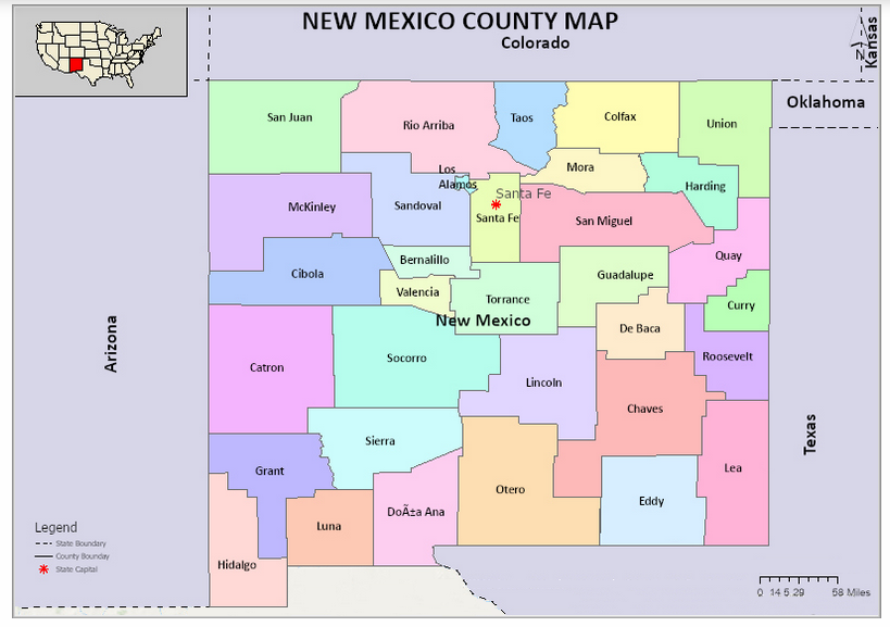
| S.N | County | County Seat | Population | Area | Formed |
|---|---|---|---|---|---|
| 1 | Bernalillo County | Albuquerque | 670968 | 1,166 mi² | 1852 |
| 2 | Catron County | Reserve | 3733 | 6,928 sq mi | 1921 |
| 3 | Chaves County | Roswell | 65890 | 6,071 sq mi | 1889 |
| 4 | Cibola County | Grants | 27658 | 4,540 sq mi | 1981 |
| 5 | Colfax County | Raton | 13640 | 3,757 sq mi | 1869 |
| 6 | Curry County | Clovis | 49649 | 1,406 sq mi | 1909 |
| 7 | De Baca County | Fort Sumner | 1945 | 2,325 sq mi | 1917 |
| 8 | Doña Ana County | Las Cruces | 213598 | 3,807 sq mi | 1852 |
| 9 | Eddy County | Carlsbad | 54152 | 4,182 sq mi | 1887 |
| 10 | Grant County | Silver City | 29380 | 3,966 sq mi | 1868 |
| 11 | Guadalupe County | Santa Rosa | 4619 | 3,031 sq mi | 1891 |
| 12 | Harding County | Mosquero | 740 | 2,126 sq mi | 1921 |
| 13 | Hidalgo County | Lordsburg | 4861 | 3,446 sq mi | 1920 |
| 14 | Lea County | Lovington | 65423 | 4,393 sq mi | 1917 |
| 15 | Lincoln County | Carrizozo | 20454 | 4,831 sq mi | 1869 |
| 16 | Los Alamos County | Los Alamos | 18222 | 109 sq mi | 1949 |
| 17 | Luna County | Deming | 25281 | 2,965 sq mi | 1901 |
| 18 | McKinley County | Gallup | 73664 | 5,449 sq mi | 1899 |
| 19 | Mora County | Mora | 4773 | 1,931 sq mi | 1859 |
| 20 | Otero County | Alamogordo | 65703 | 6,627 sq mi | 1899 |
| 21 | Quay County | Tucumcari | 9026 | 2,855 sq mi | 1903 |
| 22 | Rio Arriba County | Tierra Amarilla | 40446 | 5,858 sq mi | 1852 |
| 23 | Roosevelt County | Portales | 20446 | 2,449 sq mi | 1903 |
| 24 | San Juan County | Aztec | 128200 | 5,514 sq mi | 1887 |
| 25 | San Miguel County | Las Vegas | 29301 | 4,717 sq mi | 1852 |
| 26 | Sandoval County | Bernalillo | 134259 | 3,710 sq mi | 1903 |
| 27 | Santa Fe County | Santa Fe | 145648 | 1,909 sq mi | 1852 |
| 28 | Sierra County | Truth or Consequences | 11943 | 4,180 sq mi | 1884 |
| 29 | Socorro County | Socorro | 17873 | 6,647 sq mi | 1852 |
| 30 | Taos County | Taos | 32917 | 2,203 sq mi | 1852 |
| 31 | Torrance County | Estancia | 16345 | 3,345 sq mi | 1903 |
| 32 | Union County | Clayton | 4433 | 3,830 sq mi | 1893 |
| 33 | Valencia County | Los Lunas | 77070 | 1,068 sq mi | 1852 |
1. Catron County
County Seat: Reserve
- Area: 6,929 square miles
- Population: 3,579 (as of 2020 census)
- Area Codes: 575
- Latitude: 33.8797° N
- Longitude: 108.8966° W
Location and History
Catron County is located in western New Mexico, bordered by Arizona to the west. It is the largest county in New Mexico by area, yet it is one of the least populated. Catron County was established in 1921 and named after Thomas Benton Catron, a U.S. Senator and a leading figure in New Mexico’s early history. The county’s rugged terrain includes portions of the Gila National Forest and the Continental Divide. Historically, the area was inhabited by Apache and Navajo tribes before European exploration.
Major Highways and Landmarks
Catron County is traversed by U.S. Route 60 and New Mexico State Road 12, which connect various small communities within the county. The Gila Wilderness, a major landmark, is one of the largest wilderness areas in the United States, offering a pristine environment for hiking, camping, and wildlife observation. Other significant landmarks include the Apache Creek Pueblo, a prehistoric archaeological site, and the Plains of San Agustin, known for its large, ancient lake bed.
2. Chaves County
County Seat: Roswell
- Area: 6,071 square miles
- Population: 64,615 (as of 2020 census)
- Area Codes: 575
- Latitude: 33.3943° N
- Longitude: 104.5230° W
Location and History
Chaves County is located in southeastern New Mexico, with its county seat, Roswell, serving as the largest city. Established in 1889, Chaves County was named after José Francisco Chaves, a prominent figure in New Mexico’s territorial history. The county is historically significant due to the 1947 Roswell Incident, an event that has cemented Roswell’s place in UFO lore and pop culture. The area was traditionally inhabited by Native American tribes, and later saw significant ranching and agricultural development.
Major Highways and Landmarks
U.S. Highways 70, 285, and 380 intersect in Roswell, making it a key transportation hub in southeastern New Mexico. The International UFO Museum and Research Center in Roswell is a major tourist attraction, drawing visitors interested in the alleged UFO crash of 1947. Bitter Lake National Wildlife Refuge, located northeast of Roswell, is another important landmark, providing a habitat for migratory birds and other wildlife. Additionally, Bottomless Lakes State Park offers scenic views and recreational activities.
3. Cibola County
County Seat: Grants
- Area: 4,539 square miles
- Population: 27,172 (as of 2020 census)
- Area Codes: 505
- Latitude: 35.0763° N
- Longitude: 107.9010° W
Location and History
Cibola County, located in western New Mexico, was established in 1981, making it one of the youngest counties in the state. The county was formed from the western portion of Valencia County and is named after the legendary Seven Cities of Cibola, which were sought by Spanish explorers in the 16th century. The county has a rich cultural history, with ties to both Pueblo and Navajo communities, and includes several Native American reservations.
Major Highways and Landmarks
Interstate 40 and U.S. Route 66 (now decommissioned) run through Cibola County, providing vital transportation links. The county is home to the El Malpais National Monument, known for its unique volcanic landscape, and Acoma Pueblo, one of the oldest continuously inhabited communities in North America. Mount Taylor, a sacred mountain to several Native American tribes, is another significant landmark, offering hiking and panoramic views.
4. San Juan County
County Seat: Aztec
- Area: 5,538 square miles
- Population: 121,661 (as of 2020 census)
- Area Codes: 505
- Latitude: 36.5286° N
- Longitude: 108.0445° W
Location and History
San Juan County is located in the northwestern corner of New Mexico, bordering Arizona, Utah, and Colorado. Established in 1887, it was named after the San Juan River, which flows through the county. The area has a rich history of Native American habitation, particularly by the Navajo Nation, which occupies a significant portion of the county. The county’s economy has traditionally been based on natural resources, including oil, gas, and coal.
Major Highways and Landmarks
San Juan County is served by U.S. Highways 64, 550, and 491. The county is famous for the Aztec Ruins National Monument, a well-preserved example of Ancestral Puebloan architecture. The Bisti/De-Na-Zin Wilderness offers a unique landscape of badlands, while the San Juan River is renowned for its world-class trout fishing. The Four Corners Monument, where New Mexico, Arizona, Utah, and Colorado meet, is another notable landmark.
5. Socorro County
County Seat: Socorro
- Area: 6,649 square miles
- Population: 16,595 (as of 2020 census)
- Area Codes: 575
- Latitude: 34.0584° N
- Longitude: 106.8914° W
Location and History
Socorro County is located in central New Mexico, encompassing a large area that includes the Rio Grande River. The county was one of the original nine established when New Mexico became a U.S. Territory in 1852. The name “Socorro” means “help” or “aid,” referencing the assistance provided by the Piro Indians to the early Spanish colonists. The county has a deep historical connection to the Spanish colonial period and was a key location during the westward expansion of the United States.
Major Highways and Landmarks
Interstate 25 runs north-south through Socorro County, providing a major transportation corridor. U.S. Route 60 also passes through the county. The Very Large Array (VLA), a radio astronomy observatory, is one of the county’s most famous landmarks, known for its enormous dish antennas. Bosque del Apache National Wildlife Refuge, located along the Rio Grande, is another major site, particularly famous for birdwatching during the winter migration season.
6. McKinley County
County Seat: Gallup
- Area: 5,455 square miles
- Population: 72,902 (as of 2020 census)
- Area Codes: 505
- Latitude: 35.5054° N
- Longitude: 108.7426° W
Location and History
McKinley County, situated in the western part of New Mexico, was established in 1901 and named after President William McKinley. The county has a diverse cultural history, heavily influenced by Navajo, Zuni, and Hopi populations. Gallup, the county seat, has long been a hub for trade and commerce, especially during the railroad era. The region has a history of uranium mining, which played a significant role in its mid-20th-century economy.
Major Highways and Landmarks
Interstate 40 and U.S. Route 491 are major highways in McKinley County, facilitating travel through the region. Gallup is famous for its annual Inter-Tribal Indian Ceremonial, a major event celebrating Native American culture. The county is also home to the Zuni Pueblo, known for its rich artistic heritage, and the Red Rock Park, which features striking red sandstone formations. Chaco Culture National Historical Park, although partially in San Juan County, is easily accessible from McKinley County and is a UNESCO World Heritage site.
7. Grant County
County Seat: Silver City
- Area: 3,967 square miles
- Population: 27,767 (as of 2020 census)
- Area Codes: 575
- Latitude: 32.7799° N
- Longitude: 108.3923° W
Location and History
Grant County is located in the southwestern part of New Mexico, bordering Arizona. It was established in 1868 and named after Ulysses S. Grant, the 18th President of the United States. The county is historically significant due to its mining heritage, particularly for copper, silver, and gold. Silver City, the county seat, developed during the mining boom of the late 19th century and has since grown into a cultural and educational center.
Major Highways and Landmarks
U.S. Routes 180 and 90 are the main highways in Grant County. The county is home to the Gila Cliff Dwellings National Monument, an important archaeological site showcasing the remains of ancient Native American dwellings. The Gila National Forest, which covers much of the county, offers extensive opportunities for outdoor recreation, including hiking, camping, and birdwatching. The historic downtown of Silver City, with its well-preserved architecture and vibrant arts scene, is also a major attraction.
8. Otero County
County Seat: Alamogordo
- Area: 6,628 square miles
- Population: 67,839 (as of 2020 census)
- Area Codes: 575
- Latitude: 32.6519° N
- Longitude: 105.9787° W
Location and History
Otero County is located in southern New Mexico, bordered by Texas to the east. Established in 1899, the county was named after Miguel Antonio Otero, the governor of the New Mexico Territory at the time. The county has a rich history connected to Native American cultures, the U.S. military, and the space program. Alamogordo, the county seat, is known for its proximity to the White Sands National Park and the Holloman Air Force Base.
Major Highways and Landmarks
U.S. Routes 54, 70, and 82 are the major highways serving Otero County. The county is best known for White Sands National Park, which features vast gypsum sand dunes and is a major tourist attraction. The nearby White Sands Missile Range, a military testing area, played a significant role in the development of space exploration technology. Another landmark is the Lincoln National Forest, which offers diverse landscapes ranging from desert to alpine environments.
9. Lincoln County
County Seat: Carrizozo
- Area: 4,831 square miles
- Population: 19,572 (as of 2020 census)
- Area Codes: 575
- Latitude: 33.5133° N
- Longitude: 105.3847° W
Location and History
Lincoln County is situated in central New Mexico and is famous for its wild west history, particularly the Lincoln County War, a series of 19th-century conflicts involving famous figures like Billy the Kid. The county was established in 1869 and named after President Abraham Lincoln. Historically, the region was an important area for cattle ranching and later saw the development of tourism, particularly in the Ruidoso area.
Major Highways and Landmarks
U.S. Route 380 runs through Lincoln County, connecting key locations such as Carrizozo and Capitan. The county is known for the Lincoln Historic Site, which preserves buildings from the Lincoln County War era. Ruidoso, a popular mountain resort town, offers skiing in the winter and horse racing in the summer at Ruidoso Downs. The Mescalero Apache Reservation, home to the Mescalero Apache Tribe, is another significant area, offering cultural insights and natural beauty.
10. Sandoval County
County Seat: Bernalillo
- Area: 3,716 square miles
- Population: 148,834 (as of 2020 census)
- Area Codes: 505
- Latitude: 35.4251° N
- Longitude: 106.4132° W
Location and History
Sandoval County is located in north-central New Mexico, just north of Albuquerque. Established in 1903, the county was named after the prominent Sandoval family, who were early Spanish settlers in the area. The county has a diverse history, with influences from Native American tribes, Spanish colonists, and Mexican settlers. It includes several Pueblo communities, which have maintained their cultural heritage for centuries.
Major Highways and Landmarks
Interstate 25 and U.S. Route 550 are the primary highways in Sandoval County. The county is home to significant landmarks such as the Jemez Mountains, known for their stunning scenery and outdoor recreational opportunities, and the Bandelier National Monument, which preserves ancient Puebloan cliff dwellings. The county seat, Bernalillo, hosts the annual Las Fiestas de San Lorenzo, a cultural celebration with deep historical roots. The Santa Ana Star Casino and the Hyatt Regency Tamaya Resort, located on the Santa Ana Pueblo, are major attractions for visitors.
Counties of New Mexico
- Bernalillo County, NM
- Catron County, NM
- Chaves County, NM
- Cibola County, NM
- Colfax County, NM
- Curry County, NM
- De Baca County, NM
- Doña Ana County, NM
- Eddy County, NM
- Grant County, NM
- Guadalupe County, NM
- Harding County, NM
- Hidalgo County, NM
- Lea County, NM
- Lincoln County, NM
- Los Alamos County, NM
- Luna County, NM
- McKinley County, NM
- Mora County, NM
- Otero County, NM
- Quay County, NM
- Rio Arriba County, NM
- Roosevelt County, NM
- Sandoval County, NM
- San Juan County, NM
- San Miguel County, NM
- Santa Fe County, NM
- Sierra County, NM
- Socorro County, NM
- Taos County, NM
- Torrance County, NM
- Union County, NM
- Valencia County, NM